FAA INFORMATION EFFECTIVE 11 JUNE 2026
Location
| FAA Identifier: | AUS |
| Lat/Long: | 30-11-40.2980N 097-40-11.5540W
30-11.671633N 097-40.192567W
30.1945272,-97.6698761
(estimated) |
| Elevation: | 541.5 ft. / 165.0 m (surveyed) |
| Variation: | 04E (2020) |
| From city: | 5 miles SE of AUSTIN, TX |
| Time zone: | UTC -5 (UTC -6 during Standard Time) |
| Zip code: | 78719 |
Airport Operations
| Airport use: | Open to the public |
| Activation date: | 07/1943 |
| Control tower: | yes |
| ARTCC: | HOUSTON CENTER |
| FSS: | SAN ANGELO FLIGHT SERVICE STATION |
| NOTAMs facility: | AUS (NOTAM-D service available) |
| Attendance: | CONTINUOUS |
| Wind indicator: | lighted |
| Segmented circle: | no |
| Lights: | SS-SR |
| Beacon: | white-green (lighted land airport)
Operates sunset to sunrise. |
| Fire and rescue: | ARFF index D |
| International operations: | customs landing rights airport |
Airport Communications
| UNICOM: | 122.95 |
| WX ASOS: | PHONE 512-369-7881 |
| AUSTIN GROUND: | 121.9 348.6 121.7 |
| AUSTIN TOWER: | 121.0 281.5 118.225 254.25 |
| AUSTIN APPROACH: | 119.0 ;WEST 120.875 ;SOUTH 127.225 ;EAST 270.25 ;SOUTH 317.65 ;EAST 370.85 ;WEST |
| AUSTIN DEPARTURE: | 119.0 ;WEST 120.875 ;SOUTH 127.225 ;EAST 270.25 ;SOUTH 317.65 ;EAST 370.85 ;WEST |
| CLEARANCE DELIVERY: | 125.5 263.0 |
| AEROZ DP: | 119.0 317.65 |
| AUSTIN DP: | 119.0 370.85 |
| BITER STAR: | 127.225 317.65 |
| BLEWE STAR: | 127.225 317.65 |
| BNDIA DP: | 119.0 370.85 |
| CENTEX DP: | 127.225 317.65 |
| CLASS C: | 118.15 ;SFC-80 WEST 119.0 ;85 & ABV WEST 120.875 ;SFC - 8,000 FT, EAST 120.875 ;SFC-80 EAST 120.875 ;SOUTH 127.225 ;85 & ABV EAST 270.25 ;SFC-80 EAST 270.25 ;SOUTH 317.65 ;85 & ABV EAST 350.25 ;SFC-80 WEST 370.85 ;85 & ABV WEST |
| D-ATIS: | 124.4 |
| DXEEE STAR: | 119.0 370.85 |
| ELOEL DP: | 119.0 370.85 |
| FINAL: | 125.325 279.55 ;AS ASIGNED |
| IC: | 119.0 ;WEST 120.875 ;SOUTH 127.225 ;EAST 270.25 ;SOUTH 317.65 ;EAST 370.85 ;WEST |
| ILEXY DP: | 127.225 317.65 |
| LAIKS STAR: | 119.0 ;WEST 370.85 ;WEST |
| MUCKY DP: | 119.0 370.85 |
| PALMS DP: | 127.225 ;EAST 317.65 ;EAST |
| RAMP CTL: | 126.225 |
| SAYBR DP: | 127.225 317.65 |
| SEWZY STAR: | 127.225 317.65 |
| SZAGI STAR: | 118.15 ;SFC-7000 FT 119.0 ;8,000-12,000 FT 350.25 ;SFC-7000 FT 370.85 ;8,000-12,000 FT |
| WLEEE STAR: | 127.225 317.65 |
| WX AWOS-3 at EDC (13 nm NE): | 118.825 (512-616-2967) |
- SAID IN USE. OPERATE TRANSPONDERS WITH ALTITUDE REPORTING MODE AND ADS-B (IF EQUIPPED) ENABLED ON ALL AIRPORT SURFACES.
Nearby radio navigation aids
| VOR radial/distance | | VOR name | | Freq | | Var |
|---|
| CWKr207/13.2 | | CENTEX VORTAC | | 112.80 | | 06E |
Airport Services
| Fuel available: | 100LL JET-A |
| Parking: | hangars and tiedowns |
| Airframe service: | MINOR |
| Powerplant service: | MINOR |
| Bottled oxygen: | HIGH/LOW |
Runway Information
Runway 18R/36L
| Dimensions: | 12250 x 150 ft. / 3734 x 46 m |
| Surface: | concrete/grooved, in good condition |
| Weight bearing capacity: | | Single wheel: | 120.0 | | Double wheel: | 250.0 | | Double tandem: | 550.0 | | Dual double tandem: | 1120.0 |
|
| Runway edge lights: | high intensity |
| RUNWAY 18R | | RUNWAY 36L |
| Latitude: | 30-12.816968N | | 30-10.796593N |
| Longitude: | 097-40.761887W | | 097-40.708482W |
| Elevation: | 541.4 ft. | | 487.3 ft. |
| Traffic pattern: | right | | left |
| Runway heading: | 175 magnetic, 179 true | | 355 magnetic, 359 true |
| Declared distances: | TORA:12250 TODA:12250 ASDA:12250 LDA:12250 | | TORA:12250 TODA:12250 ASDA:12250 LDA:12250 |
| Markings: | precision, in good condition | | precision, in good condition |
| Visual slope indicator: | 4-light PAPI on left (3.00 degrees glide path) | | 4-light PAPI on left (3.00 degrees glide path) |
| RVR equipment: | touchdown, rollout | | touchdown, rollout |
| Approach lights: | MALS: 1,400 foot medium intensity approach lighting system | | MALS: 1,400 foot medium intensity approach lighting system |
| Runway end identifier lights: | no | | no |
| Touchdown point: | yes, no lights | | yes, no lights |
| Instrument approach: | ILS/DME | | ILS/DME |
Runway 18L/36R
| Dimensions: | 9000 x 150 ft. / 2743 x 46 m |
| Surface: | concrete/grooved, in good condition |
| Weight bearing capacity: | | Single wheel: | 120.0 | | Double wheel: | 250.0 | | Double tandem: | 513.0 | | Dual double tandem: | 1033.0 |
|
| Runway edge lights: | high intensity |
| RUNWAY 18L | | RUNWAY 36R |
| Latitude: | 30-12.229803N | | 30-10.745462N |
| Longitude: | 097-39.473463W | | 097-39.434600W |
| Elevation: | 491.6 ft. | | 473.6 ft. |
| Traffic pattern: | left | | right |
| Runway heading: | 175 magnetic, 179 true | | 355 magnetic, 359 true |
| Declared distances: | TORA:9000 TODA:9000 ASDA:9000 LDA:9000 | | TORA:9000 TODA:9000 ASDA:9000 LDA:9000 |
| Markings: | precision, in good condition | | precision, in good condition |
| Visual slope indicator: | 4-light PAPI on left (3.00 degrees glide path) | | 4-light PAPI on left (3.00 degrees glide path) |
| RVR equipment: | touchdown, midfield, rollout | | touchdown, midfield, rollout |
| Approach lights: | ALSF2: standard 2,400 foot high intensity approach lighting system with centerline sequenced flashers (category II or III) | | MALSR: 1,400 foot medium intensity approach lighting system with runway alignment indicator lights |
| Runway end identifier lights: | no | | no |
| Centerline lights: | yes | | yes |
| Touchdown point: | yes, lighted | | yes, lighted |
| Instrument approach: | ILS/DME | | ILS/DME |
| Obstructions: | 90 ft. tower, lighted, 3807 ft. from runway, 236 ft. right of centerline, 40:1 slope to clear | | none |
Helipad H1
| Dimensions: | 60 x 60 ft. / 18 x 18 m |
| Surface: | concrete, in good condition |
| Latitude: | 30-11.128500N | | |
| Longitude: | 097-39.660333W | | |
| Elevation: | 541.5 ft. | | |
| Traffic pattern: | left | | left |
| Markings: | none, in good condition | | |
Helipad H2
| Dimensions: | 60 x 60 ft. / 18 x 18 m |
| Surface: | concrete, in good condition |
| Latitude: | 30-11.260333N | | |
| Longitude: | 097-39.664000W | | |
| Elevation: | 541.5 ft. | | |
| Traffic pattern: | left | | left |
| Markings: | none, in good condition | | |
Helipad H3
| Dimensions: | 50 x 50 ft. / 15 x 15 m |
| Surface: | concrete, in good condition |
| Latitude: | 30-10.769167N | | |
| Longitude: | 097-40.392500W | | |
| Elevation: | 479.0 ft. | | |
| Traffic pattern: | left | | left |
| Markings: | basic, in good condition | | |
Airport Ownership and Management from official FAA records
| Ownership: | Publicly-owned |
| Owner: | CITY OF AUSTIN
PO BOX 1088
AUSTIN, TX 78767
Phone 512-974-2000 |
| Manager: | GHIZLANE BADAWI
3600 PRESIDENTIAL BLVD, SUITE 411
AUSTIN, TX 78719
Phone 512-530-8846
GHIZLANE.BADAWI@FLYAUSTIN.COM |
Additional Remarks
| A39-18R/36L | PCR VALUE: 1070/R/B/W/T |
| A39-18L/36R | PCR VALUE: 900/R/B/W/T |
| - | BIRD ACTIVITY ON & INVOF ARPT. |
| - | PPR GA ACFT ON THE PSGR TERMINAL APRON, CALL OPS 512-530-7550. |
| - | ARNG: OPR 1300-2300++ TUE-FRI, DSN 954-5001 EXT 7024614, C512-356-7900 EXT 7024614. |
| - | TWY A CLSD TO ACFT WITH WINGSPAN MORE THAN 171 FT. |
| - | PPR FOR NON STATE OF TEXAS AIRCRAFT ENTERING THE STATE RAMP ABEAM TWY E. CALL STATE OPS 512-936-8900 OR FREQ. 131.375. |
| - | TXLN R4 CLSD TO AFCT WITH WINGSPAN MORE THAN 135. |
| - | TXLN C2 CLSD TO AFCT WITH WINGSPAN MORE THAN 171. |
| - | TXLN R1, R3, R5 CLSD TO AFCT WITH WINGSPAN MORE THAN 118. |
| - | TXLN C2 BTWN TWY C AND G1, AND TXLN R1 CLSD 2000L-0800L. |
| - | CTC RAMP CTL AT 126.225 PRIOR TO ENTRY/EXIT TO/FM THE TRML APN. |
| - | DURG THE HRS 0000-0600 ARRG ACFT WILL BE ASGND RWY 36L OR RWY 36R & DEPARTING ACFT WILL BE ASGND RWY 18L OR RWY 18R TO AVOID NOISE SENSITIVE AREAS. |
| - | NOISE ABATEMENT: ALL DEP FOLLOW ATC INSTRUCTIONS; CLIMB ASAP TO 4000 FT OR ABOVE. |
| - | PPR ENGINE MAINTENANCE RUN UPS CALL OPS 512-530-7550. |
Instrument Procedures
NOTE: All procedures below are presented as PDF files. If you need a reader for these files, you should download the free Adobe Reader.NOT FOR NAVIGATION. Please procure official charts for flight.
FAA instrument procedures published for use from 11 June 2026 at 0901Z to 09 July 2026 at 0900z.
STARs - Standard Terminal Arrivals |
|---|
| BLEWE FIVE **NEW** | |
download (157KB) |
| DXEEE THREE (RNAV) **NEW** | |
download (252KB) |
| LAIKS FOUR (RNAV) **NEW** | |
download (258KB) |
| SEWZY SIX (RNAV) **NEW** | |
download (206KB) |
| SZAGI THREE (RNAV) **NEW** | |
download (196KB) |
| WLEEE SEVEN (RNAV) **NEW** | |
2 pages:
[1] [2] (341KB) |
IAPs - Instrument Approach Procedures |
|---|
| ILS OR LOC RWY 18L | |
download (308KB) |
| ILS OR LOC RWY 18R | |
download (285KB) |
| ILS OR LOC RWY 36L | |
download (274KB) |
| ILS OR LOC RWY 36R | |
download (258KB) |
| ILS RWY 18L (SA CAT I) | |
download (277KB) |
| ILS RWY 36R (SA CAT I - II) | |
download (254KB) |
| ILS RWY 18L (CAT II - III) | |
download (275KB) |
| RNAV (RNP) Z RWY 18L | |
download (255KB) |
| RNAV (RNP) Z RWY 18R | |
download (239KB) |
| RNAV (RNP) Z RWY 36L | |
download (266KB) |
| RNAV (RNP) Z RWY 36R | |
download (272KB) |
| RNAV (GPS) Y RWY 18L | |
download (264KB) |
| RNAV (GPS) Y RWY 18R | |
download (257KB) |
| RNAV (GPS) Y RWY 36L | |
download (254KB) |
| RNAV (GPS) Y RWY 36R | |
download (244KB) |
Departure Procedures |
|---|
| AEROZ TWO (RNAV) | |
download (167KB) |
| AUSTIN SEVEN | |
2 pages:
[1] [2] (292KB) |
| BNDIA THREE (RNAV) | |
download (155KB) |
| CENTEX EIGHT | |
2 pages:
[1] [2] (395KB) |
| ELOEL THREE (RNAV) | |
download (180KB) |
| ILEXY FOUR (RNAV) | |
download (196KB) |
| MUCKY THREE (RNAV) | |
download (155KB) |
| PALMS FOUR | |
download (154KB) |
| SAYBR THREE (RNAV) | |
download (164KB) |
| NOTE: Special Take-Off Minimums/Departure Procedures apply | |
download (303KB) |
Other nearby airports with instrument procedures:
KEDC - Austin Executive Airport (13 nm NE)
3R9 - Lakeway Airpark (19 nm NW)
50R - Lockhart Municipal Airport (21 nm S)
KHYI - San Marcos Regional Airport (21 nm SW)
KRYW - Lago Vista TX/Rusty Allen Airport (24 nm NW)
|
|

Road maps at:
MapQuest
Bing
Google
| Aerial photo |
|---|
WARNING: Photo may not be current or correct
 Photo by C. Barry Turner
Photo taken 30-Jan-2019
looking northeast.
Photo by C. Barry Turner
Photo taken 30-Jan-2019
looking northeast.
Do you have a better or more recent aerial photo of Austin-Bergstrom International Airport that you would like to share? If so, please send us your photo.
|
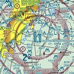
| Sectional chart |
|---|
|
CAUTION: Diagram may not be current
 Download PDF
of official airport diagram from the FAA
| Airport distance calculator |
|---|
|
|
| Sunrise and sunset |
|---|
|
Times for 12-Jun-2026
| | Local
(UTC-5) | | Zulu
(UTC) |
|---|
| Morning civil twilight | | 06:02 | | 11:02 |
| Sunrise | | 06:29 | | 11:29 |
| Sunset | | 20:32 | | 01:32 |
| Evening civil twilight | | 20:59 | | 01:59 |
|
| Current date and time |
|---|
| Zulu (UTC) | 12-Jun-2026 06:10:43 |
|---|
| Local (UTC-5) | 12-Jun-2026 01:10:43 |
|---|
|
| METAR |
|---|
KAUS
6nm N | 120553Z 16007KT 10SM BKN015 27/24 A2993 RMK AO2 SLP122 T02670239 10333 20267 403390250 51024
|
KATT
7nm N | 120551Z AUTO 17007KT 10SM OVC016 27/24 A2995 RMK AO1 SLP125 T02670244 10317 20267 403440256 51024 $
|
|
| TAF |
|---|
KAUS
6nm N | 120525Z 1206/1312 17009KT P6SM SCT015 FM120630 17008KT P6SM BKN015 FM121600 16009KT P6SM SCT015 BKN025 FM121700 16012G22KT P6SM BKN035 FM130300 16008KT P6SM SCT040
|
|
| NOTAMs |
|---|
NOTAMs are issued by the DoD/FAA and will open in a separate window not controlled by AirNav.
|
|


