FAA INFORMATION EFFECTIVE 16 APRIL 2026
Location
| FAA Identifier: | EMT |
| Lat/Long: | 34-05-09.6320N 118-02-05.4430W
34-05.160533N 118-02.090717W
34.0860089,-118.0348453
(estimated) |
| Elevation: | 295.6 ft. / 90.1 m (surveyed) |
| Variation: | 14E (1985) |
| From city: | 1 mile N of EL MONTE, CA |
| Time zone: | UTC -7 (UTC -8 during Standard Time) |
| Zip code: | 91731 |
Airport Operations
| Airport use: | Open to the public |
| Activation date: | 04/1944 |
| Control tower: | yes |
| ARTCC: | LOS ANGELES CENTER |
| FSS: | RIVERSIDE FLIGHT SERVICE STATION |
| NOTAMs facility: | EMT (NOTAM-D service available) |
| Attendance: | CONTINUOUS |
| Wind indicator: | lighted |
| Segmented circle: | yes |
| Lights: | WHEN ATCT CLSD ACTVT REIL RWY 19, MIRL RWY 01/19 - CTAF. |
| Beacon: | white-green (lighted land airport)
Operates sunset to sunrise. |
| Taxiway lights: | CNTR TWY LGTS ONLY. |
Airport Communications
| CTAF: | 121.2 |
| UNICOM: | 122.95 |
| ATIS: | 118.75 |
| WX AWOS-3PT: | 118.75 ((626) 444-1107) |
| EL MONTE GROUND: | 125.9 [0800-2000] |
| EL MONTE TOWER: | 121.2 [0800-2000] |
| SOCAL APPROACH: | 125.5 ;SW-NORTH |
| SOCAL DEPARTURE: | 125.5 ;SW-NORTH |
| CLASS C: | 127.0 ;NORTH-NE |
| IC: | 125.5 ;SW-NORTH |
| SETER STAR: | 127.0 |
| ZIGGY STAR: | 127.0 |
| WX AWOS-3PT at POC (13 nm E): | PHONE 909-962-5407 |
| WX ASOS at FUL (13 nm S): | PHONE 714-870-1372 |
| WX AWOS-3PT at CPM (16 nm SW): | 127.150 (310-631-3022) |
| WX ASOS at LGB (17 nm S): | PHONE 562-247-0378 |
| WX AWOS-3P at CCB (17 nm E): | 119.525 (909-985-4731) |
| WX ASOS at BUR (17 nm NW): | PHONE 818-841-1384 |
| WX ASOS at HHR (18 nm SW): | PHONE 310-973-8930 |
- DRG HRS EL MONTE TWR IS OPNL SOCAL APP PRVDS DEP CTL SVC ON 125.5; OTR HRS DEP CTL ON 121.2.
Nearby radio navigation aids
| VOR radial/distance | | VOR name | | Freq | | Var |
|---|
| POMr257/12.3 | | POMONA VORTAC | | 110.40 | | 15E |
| SLIr348/18.2 | | SEAL BEACH VORTAC | | 115.70 | | 15E |
| SMOr063/21.5 | | SANTA MONICA VOR/DME | | 110.80 | | 15E |
| LAXr050/21.8 | | LOS ANGELES VORTAC | | 113.60 | | 15E |
| VNYr095/24.1 | | VAN NUYS VOR/DME | | 113.10 | | 15E |
| PDZr277/27.1 | | PARADISE VORTAC | | 112.20 | | 15E |
| ELBr314/28.9 | | EL TORO VOR/DME | | 117.20 | | 14E |
| RALr271/(30.1) | | RIVERSIDE VOR | | 108.60 | | 14E |
| PMDr162/32.8 | | PALMDALE VORTAC | | 115.55 | | 15E |
Airport Services
| Fuel available: | 100LL JET-A |
| Parking: | tiedowns |
| Airframe service: | MAJOR |
| Powerplant service: | MAJOR |
| Bulk oxygen: | NONE |
Runway Information
Runway 1/19
| Dimensions: | 3995 x 75 ft. / 1218 x 23 m |
| Surface: | asphalt/aggregate friction seal coat, in good condition |
| Weight bearing capacity: | |
| Runway edge lights: | medium intensity |
| RUNWAY 1 | | RUNWAY 19 |
| Latitude: | 34-04.862517N | | 34-05.457367N |
| Longitude: | 118-02.260400W | | 118-01.920483W |
| Elevation: | 281.8 ft. | | 295.6 ft. |
| Traffic pattern: | left | | right |
| Runway heading: | 011 magnetic, 025 true | | 191 magnetic, 205 true |
| Displaced threshold: | 290 ft. | | 641 ft. |
| Declared distances: | TORA:3504 TODA:3995 ASDA:3755 LDA:3465 | | TORA:3995 TODA:3995 ASDA:3995 LDA:3354 |
| Markings: | basic, in good condition | | basic, in good condition |
| Visual slope indicator: | 2-light PAPI on left (4.57 degrees glide path) | | 2-light PAPI on right (4.50 degrees glide path) |
| Runway end identifier lights: | no | | yes |
| Touchdown point: | yes, no lights | | yes, no lights |
| Obstructions: | 18 ft. pole, 350 ft. from runway, 85 ft. right of centerline, 8:1 slope to clear
RWY 01 +6 FT FENCE 120 FT R OF CNTRLN; +6 FT FENCE 120 FT LEFT & PARALLEL TO CNTRLN 0-200 FT FM END OF RY. | | 30 ft. pole, 800 ft. from runway, 205 ft. left of centerline, 20:1 slope to clear
+2 FT FENCE 75 FT RIGHT OF CNTRLN AT THR TO 0 FT RIGHT OF CNTRLN AT 200 FT. |
Airport Ownership and Management from official FAA records
| Ownership: | Publicly-owned |
| Owner: | CO OF LOS ANGELES
P O BOX 1460
ALHAMBRA, CA 91803-1331
Phone 626-300-4600
LA COUNTY CTC: PAUL MASELBAS, 626-300-4600 X4615. |
| Manager: | SALVADOR EULLOQUI BOBADILLA
4233 SANTA ANITA AVE
EL MONTE, CA 91731
Phone 626-776-4370 |
Additional Remarks
| - | REMAIN OVER PAVED CHANNEL ON CLIMB OUT TO SOUTH AND TO NORTH. |
| - | HEAVY BIRD ACTIVITY ON & INVOF ARPT. |
| - | LGTD WATER TWR 1 MI W-SW OF ARPT. |
| - | NOISE ABATEMENT PROCEDURES IN EFFECT, CTC ARPT MANAGER FOR DETAILS. |
| - | FOR CLNC DEL WHEN ATCT CLSD CALL SOCAL APP (800) 448-3724. |
Instrument Procedures
NOTE: All procedures below are presented as PDF files. If you need a reader for these files, you should download the free Adobe Reader.NOT FOR NAVIGATION. Please procure official charts for flight.
FAA instrument procedures published for use from 16 April 2026 at 0901Z to 14 May 2026 at 0900Z.
STARs - Standard Terminal Arrivals |
|---|
| SETER FIVE **CHANGED** | |
download (244KB) |
| ZIGGY EIGHT **CHANGED** | |
2 pages:
[1] [2] (401KB) |
IAPs - Instrument Approach Procedures |
|---|
| RNAV (GPS)-B **CHANGED** | |
download (230KB) |
| VOR-A **CHANGED** | |
download (383KB) |
| NOTE: Special Alternate Minimums apply | |
download (117KB) |
| NOTE: Special Take-Off Minimums/Departure Procedures apply | |
download (236KB) |
Other nearby airports with instrument procedures:
KPOC - Brackett Field Airport (13 nm E)
KFUL - Fullerton Municipal Airport (13 nm S)
KLGB - Long Beach Airport (Daugherty Field) (17 nm S)
KCCB - Cable Airport (17 nm E)
KBUR - Bob Hope Airport (17 nm NW)
KSLI - Los Alamitos Army Airfield (18 nm S)
KHHR - Jack Northrop Field/Hawthorne Municipal Airport (18 nm SW)
|
|

Road maps at:
MapQuest
Bing
Google
| Aerial photo |
|---|
WARNING: Photo may not be current or correct
 Photo by Mark Holtzman
West Coast Aerial Photography
Photo taken 01-May-2019
looking northwest.
Do you have a better or more recent aerial photo of San Gabriel Valley Airport that you would like to share? If so, please send us your photo.
|
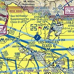
| Sectional chart |
|---|
|
CAUTION: Diagram may not be current
 Download PDF
of official airport diagram from the FAA
| Airport distance calculator |
|---|
|
|
| Sunrise and sunset |
|---|
|
Times for 30-Apr-2026
| | Local
(UTC-7) | | Zulu
(UTC) |
|---|
| Morning civil twilight | | 05:38 | | 12:38 |
| Sunrise | | 06:05 | | 13:05 |
| Sunset | | 19:34 | | 02:34 |
| Evening civil twilight | | 20:01 | | 03:01 |
|
| Current date and time |
|---|
| Zulu (UTC) | 01-May-2026 06:20:00 |
|---|
| Local (UTC-7) | 30-Apr-2026 23:20:00 |
|---|
|
| METAR |
|---|
| KEMT | 010247Z 22006KT 10SM CLR 19/12 A2988
|
KMWS
8nm N | 010520Z 17002G05KT 14/01
|
KPOC
13nm E | 010347Z 25006KT 10SM CLR 17/12 A2992 RMK LAST
|
KFUL
13nm S | 010553Z AUTO 00000KT 10SM CLR 16/13 A2992 RMK AO2 SLP130 T01610133 10211 20161 51017
|
KLGB
17nm S | 010553Z AUTO 15003KT 10SM CLR 17/13 A2992 RMK AO2 SLP131 T01670128 10217 20161 51017
|
KCCB
17nm E | 119.525 909-985-4731
010555Z AUTO 27005KT 10SM CLR 15/13 A2993 RMK AO2
|
KBUR
18nm NW | 010553Z 21004KT 10SM CLR 15/12 A2993 RMK AO2 SLP125 T01500122 10217 20150 51019
|
KHHR
18nm SW | 010553Z 00000KT 10SM CLR 16/13 A2993 RMK AO2 SLP133 T01610128 10194 20161 51015
|
KSLI
19nm S | 010555Z AUTO 00000KT 8SM FEW015 16/14 A2989 RMK AO2 SLP125 T01600137 10206 20160 51015
|
KLAX
20nm SW | 010553Z 18003KT 10SM FEW012 SCT016 16/13 A2992 RMK AO2 SLP131 T01610133 10183 20156 51014
|
|
| TAF |
|---|
KLGB
17nm S | 010534Z 0106/0206 VRB03KT P6SM SKC FM010800 VRB03KT P6SM OVC012 FM011800 19008KT P6SM SKC FM020100 30010KT P6SM SKC
|
KBUR
18nm NW | 010534Z 0106/0206 VRB03KT P6SM SKC FM010900 VRB03KT 5SM BR OVC008 FM011700 VRB03KT P6SM SKC FM012100 19008KT P6SM SKC FM020400 VRB03KT P6SM SKC
|
KSLI
19nm S | 010500Z 0105/0211 VRB06KT 9999 FEW015 QNH2986INS TEMPO 0108/0115 BKN015 BECMG 0116/0117 VRB06KT 9999 SKC QNH2992INS BECMG 0120/0121 23010G20KT 9999 SKC QNH2986INS BECMG 0209/0210 VRB06KT 8000 -RA OVC005 QNH2993INS TX24/0123Z TN15/0111Z
|
KLAX
20nm SW | 010534Z 0106/0212 VRB03KT P6SM SCT015 FM010800 VRB03KT P6SM OVC012 FM011800 24006KT P6SM SCT015 FM012000 26012KT P6SM FEW015 FM020300 VRB03KT P6SM OVC010
|
KSMO
21nm W | 010534Z 0106/0206 VRB03KT P6SM OVC012 FM011800 21006KT P6SM SCT015 FM012000 23010KT P6SM SKC FM020300 22005KT P6SM BKN010
|
|
| NOTAMs |
|---|
NOTAMs are issued by the DoD/FAA and will open in a separate window not controlled by AirNav.
|
|


