FAA INFORMATION EFFECTIVE 16 APRIL 2026
Location
| FAA Identifier: | GRE |
| Lat/Long: | 38-50-10.4000N 089-22-44.0000W
38-50.173333N 089-22.733333W
38.8362222,-89.3788889
(estimated) |
| Elevation: | 540.8 ft. / 164.8 m (surveyed) |
| Variation: | 02W (2020) |
| From city: | 3 miles S of GREENVILLE, IL |
| Time zone: | UTC -5 (UTC -6 during Standard Time) |
| Zip code: | 62246 |
Airport Operations
| Airport use: | Open to the public |
| Control tower: | no |
| ARTCC: | KANSAS CITY CENTER |
| FSS: | SAINT LOUIS FLIGHT SERVICE STATION |
| NOTAMs facility: | STL (NOTAM-D service available) |
| Attendance: | 0730-1700 |
| Pattern altitude: | 1340.8 ft. MSL |
| Wind indicator: | lighted |
| Segmented circle: | no |
| Lights: | MIRL RY 18/36 PRESET ON MED INTST; TO INCR INTST ACTVT - CTAF. |
| Beacon: | white-green (lighted land airport)
Operates sunset to sunrise. |
Airport Communications
| CTAF/UNICOM: | 123.05 |
| WX AWOS-2: | 120.0 (618-664-1939) |
| WX AWOS-AV at VLA (14 nm NE): | 122.8 (618-283-9595) |
- APCH/DEP SVC PRVDD BY KANSAS CITY ARTCC ON FREQS 124.3/269.15 (DECATUR RCAG)
Nearby radio navigation aids
| VOR radial/distance | | VOR name | | Freq | | Var |
|---|
| TOYr073/25.9 | | TROY VORTAC | | 116.00 | | 04E |
| ENLr334/27.0 | | CENTRALIA VORTAC | | 115.00 | | 04E |
Airport Services
| Fuel available: | 100LL JET-A |
| Parking: | hangars and tiedowns |
| Airframe service: | NONE |
| Powerplant service: | NONE |
| Bottled oxygen: | NONE |
| Bulk oxygen: | NONE |
Runway Information
Runway 18/36
| Dimensions: | 4002 x 75 ft. / 1220 x 23 m |
| Surface: | asphalt, in good condition |
| Weight bearing capacity: | |
| Runway edge lights: | medium intensity |
| RUNWAY 18 | | RUNWAY 36 |
| Latitude: | 38-50.470900N | | 38-49.811675N |
| Longitude: | 089-22.587583W | | 089-22.583670W |
| Elevation: | 540.1 ft. | | 531.7 ft. |
| Traffic pattern: | left | | left |
| Runway heading: | 181 magnetic, 179 true | | 001 magnetic, 359 true |
| Markings: | nonprecision, in fair condition | | nonprecision, in fair condition |
| Visual slope indicator: | pulsating/steady burning VASI on left (3.00 degrees glide path) | | |
| Runway end identifier lights: | yes | | yes |
| Touchdown point: | yes, no lights | | yes, no lights |
Runway 9/27
| Dimensions: | 2822 x 250 ft. / 860 x 76 m |
| Surface: | turf, in good condition |
| RUNWAY 9 | | RUNWAY 27 |
| Latitude: | 38-50.222495N | | 38-50.218163N |
| Longitude: | 089-23.238852W | | 089-22.644395W |
| Elevation: | 537.9 ft. | | 537.7 ft. |
| Traffic pattern: | left | | left |
| Runway heading: | 092 magnetic, 090 true | | 272 magnetic, 270 true |
| Touchdown point: | yes, no lights | | yes, no lights |
Airport Ownership and Management from official FAA records
| Ownership: | Publicly-owned |
| Owner: | THE GREENVILLE ARPT AUTHORITY
1374 SKY LANE
GREENVILLE, IL 62246
Phone 618-664-0926 |
| Manager: | LARRY KLEINER
1374 SKY LANE
GREENVILLE, IL 62246
Phone 618-664-0926
OR 618-664-3272 |
Additional Remarks
| - | INTENSIVE PARACHUTE OPS. |
| - | AWOS 3 CLICKS ON CTAF. |
| - | DOOR CODE FOR BUILDING ENTRY IS CTAF, THEN # |
| - | FOR CD CTC KANSAS CITY ARTCC AT 913-254-8508. |
Instrument Procedures
NOTE: All procedures below are presented as PDF files. If you need a reader for these files, you should download the free Adobe Reader.NOT FOR NAVIGATION. Please procure official charts for flight.
FAA instrument procedures published for use from 16 April 2026 at 0901Z to 14 May 2026 at 0900Z.
IAPs - Instrument Approach Procedures |
|---|
| RNAV (GPS) RWY 18 | |
download (208KB) |
| RNAV (GPS) RWY 36 | |
download (204KB) |
| NOTE: Special Take-Off Minimums/Departure Procedures apply | |
download (201KB) |
Other nearby airports with instrument procedures:
KVLA - Vandalia Municipal Airport (14 nm NE)
KSLO - Salem-Leckrone Airport (23 nm SE)
KENL - Centralia Municipal Airport (24 nm SE)
3LF - Litchfield Municipal Airport (24 nm NW)
KBLV - Scott Air Force Base/MidAmerica Airport (28 nm SW)
|
|

Road maps at:
MapQuest
Bing
Google
| Aerial photo |
|---|
WARNING: Photo may not be current or correct
 Photo courtesy of Cardinal Aviation Services Aerial Photography
Do you have a better or more recent aerial photo of Greenville Airport that you would like to share? If so, please send us your photo.
|
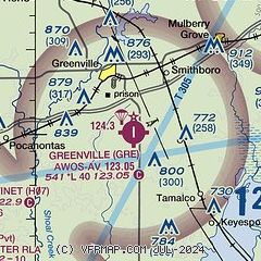
| Sectional chart |
|---|
|
| Airport distance calculator |
|---|
|
|
| Sunrise and sunset |
|---|
|
Times for 05-May-2026
| | Local
(UTC-5) | | Zulu
(UTC) |
|---|
| Morning civil twilight | | 05:27 | | 10:27 |
| Sunrise | | 05:56 | | 10:56 |
| Sunset | | 19:52 | | 00:52 |
| Evening civil twilight | | 20:21 | | 01:21 |
|
| Current date and time |
|---|
| Zulu (UTC) | 06-May-2026 00:00:23 |
|---|
| Local (UTC-5) | 05-May-2026 19:00:23 |
|---|
|
| METAR |
|---|
KSLO
22nm SE | 052335Z AUTO 02006KT 3SM RA BKN007 OVC013 10/09 A2980 RMK AO2 LTG DSNT W P0003 T00970093
|
KENL
23nm SE | 052335Z AUTO 00000KT 7SM +RA OVC006 09/09 A2981 RMK AO2 LTG DSNT NE AND SW P0002 T00930085
|
K3LF
24nm NW | 052335Z AUTO 00000KT 7SM -RA SCT011 BKN032 OVC065 07/06 A2984 RMK AO2 LTG DSNT SW P0008 T00710056
|
KBLV
28nm SW | 052343Z 35004KT 4SM -TSRA BR BKN007 OVC013 10/09 A2980 RMK AO2A RAE15DZB15E19RAB19 TSB43 CIG 006 RWY14R SLP094 $
|
KALN
31nm W | 052350Z AUTO 34007KT 6SM RA BKN009 BKN012 OVC050 08/07 A2986
|
KMVN
39nm SE | 052337Z AUTO 02007KT 5SM BR BKN009 OVC016 09/09 A2979 RMK AO2 LTG DSNT N CIG 005V012 $
|
KCPS
40nm SW | 052353Z 33010KT 6SM -RA BR BKN014 OVC024 09/07 A2984 RMK AO2 LTG DSNT SE AND S RAB00 SLP104 6//// T00890072 10122 20089 53001 PNO $
|
K1H2
42nm E | 052335Z AUTO 02003KT 5SM DZ BKN009 OVC013 09/09 A2981 RMK AO2 T00870087
|
KTAZ
42nm N | 052341Z AUTO 00000KT 7SM BKN080 OVC100 07/06 A2982 RMK AO2 P0011
|
|
| TAF |
|---|
KBLV
28nm SW | 052340Z 0523/0622 01012G18KT 8000 -SHRA OVC055 QNH2976INS TEMPO 0523/0602 4800 -TSRA OVC015CB BECMG 0605/0606 02009KT 9000 BR OVC020 QNH2980INS BECMG 0608/0609 35006KT 9999 NSW BKN080 QNH2986INS TX11/0523Z TN08/0611Z
|
|
| NOTAMs |
|---|
NOTAMs are issued by the DoD/FAA and will open in a separate window not controlled by AirNav.
|
|

