FAA INFORMATION EFFECTIVE 07 AUGUST 2025
Location
| FAA Identifier: | BOI |
| Lat/Long: | 43-33-51.7000N 116-13-22.3000W
43-33.861667N 116-13.371667W
43.5643611,-116.2228611
(estimated) |
| Elevation: | 2871.7 ft. / 875.3 m (surveyed) |
| Variation: | 13E (2020) |
| From city: | 3 miles S of BOISE, ID |
| Time zone: | UTC -6 (UTC -7 during Standard Time) |
| Zip code: | 83705 |
Airport Operations
| Airport use: | Open to the public |
| Activation date: | 04/1940 |
| Control tower: | yes |
| ARTCC: | SALT LAKE CITY CENTER |
| FSS: | BOISE FLIGHT SERVICE STATION |
| NOTAMs facility: | BOI (NOTAM-D service available) |
| Attendance: | CONTINUOUS |
| Wind indicator: | lighted |
| Segmented circle: | no |
| Lights: | SS-SR |
| Beacon: | white-green (lighted land airport)
Operates sunset to sunrise. |
| Fire and rescue: | ARFF index C |
| International operations: | customs landing rights airport
FLIGHT NOTIFICATION SVC (ADCUS) MON-FRI 0800-1700;
WKEND IF NOTIFIED BY 1700 THURS. |
Airport Communications
| UNICOM: | 122.95 |
| WX ASOS: | 123.9 (208-318-5005) |
| BOISE GROUND: | 121.7 348.6 |
| BOISE TOWER: | 118.1 257.8 119.0 |
| BIG SKY APPROACH: | 119.6 ;MORE THAN 15 NM FM BOI 126.9 ;WITHIN 15 NM OF BOI 269.4 ;SOUTH 351.85 ;NORTH |
| BIG SKY DEPARTURE: | 119.6 ;MORE THAN 15 NM FM BOI 126.9 ;WITHIN 15 NM OF BOI 269.4 ;SOUTH 351.85 ;NORTH |
| CLEARANCE DELIVERY: | 125.9 323.2 |
| ANG OPS: | 298.7 |
| CLASS C: | 119.6 ;SOUTH 126.9 ;NORTH 269.4 ;SOUTH 351.85 ;NORTH |
| D-ATIS: | 123.9 290.4 |
| EMERG: | 121.5 |
| IC: | 118.1 119.6 ;MORE THAN 15 NM FM BOI 269.4 ;SOUTH |
| WX AWOS-3 at MAN (13 nm W): | 118.325 (208 318-0040) |
| WX AWOS-3PT at EUL (19 nm W): | 135.075 (208-454-3953) |
- OR INBOUND FM HORSESHOE BEND/ALDAPE PEAK.
- ARNG OPS & ARMY R/W - D422-3976.
Nearby radio navigation aids
| VOR radial/distance | | VOR name | | Freq | | Var |
|---|
| BOIr280/1.5 | | BOISE VORTAC | | 113.30 | | 17E |
Airport Services
| Fuel available: | 100LL JET-A+ |
| Parking: | hangars and tiedowns |
| Airframe service: | MAJOR |
| Powerplant service: | MAJOR |
| Bottled oxygen: | HIGH/LOW |
| Bulk oxygen: | HIGH/LOW |
Runway Information
Runway 10L/28R
| Dimensions: | 10000 x 150 ft. / 3048 x 46 m |
| Surface: | asphalt/grooved, in good condition |
| Weight bearing capacity: | | Single wheel: | 100.0 | | Double wheel: | 210.0 | | Double tandem: | 446.0 | | Dual double tandem: | 947.0 |
|
| Runway edge lights: | high intensity |
| RUNWAY 10L | | RUNWAY 28R |
| Latitude: | 43-34.212615N | | 43-33.513250N |
| Longitude: | 116-14.214697W | | 116-12.165907W |
| Elevation: | 2830.6 ft. | | 2871.7 ft. |
| Traffic pattern: | left | | right |
| Runway heading: | 102 magnetic, 115 true | | 282 magnetic, 295 true |
| Declared distances: | TORA:10000 TODA:10000 ASDA:10000 LDA:10000 | | TORA:10000 TODA:10000 ASDA:10000 LDA:10000 |
| Markings: | nonprecision, in good condition | | precision, in good condition |
| Visual slope indicator: | 4-light PAPI on right (3.00 degrees glide path) | | 4-light PAPI on left (3.00 degrees glide path) |
| Runway end identifier lights: | yes | | |
| Touchdown point: | yes, no lights | | yes, no lights |
| Instrument approach: | | | ILS/DME |
Runway 10R/28L
| Dimensions: | 9763 x 150 ft. / 2976 x 46 m |
| Surface: | asphalt/grooved, in good condition |
| Weight bearing capacity: | | Single wheel: | 100.0 | | Double wheel: | 210.0 | | Double tandem: | 430.0 | | Dual double tandem: | 994.0 |
|
| Runway edge lights: | high intensity |
| RUNWAY 10R | | RUNWAY 28L |
| Latitude: | 43-34.202077N | | 43-33.519377N |
| Longitude: | 116-14.556973W | | 116-12.556567W |
| Elevation: | 2824.2 ft. | | 2858.3 ft. |
| Traffic pattern: | right | | left |
| Runway heading: | 102 magnetic, 115 true | | 282 magnetic, 295 true |
| Declared distances: | TORA:9763 TODA:9763 ASDA:9763 LDA:9763 | | TORA:9763 TODA:9763 ASDA:9763 LDA:9763 |
| Markings: | precision, in good condition | | precision, in good condition |
| Visual slope indicator: | 4-box VASI on left (3.00 degrees glide path) | | 4-box VASI on left (3.00 degrees glide path) |
| RVR equipment: | touchdown, midfield, rollout | | touchdown, midfield, rollout |
| Approach lights: | ALSF2: standard 2,400 foot high intensity approach lighting system with centerline sequenced flashers (category II or III) | | MALSR: 1,400 foot medium intensity approach lighting system with runway alignment indicator lights |
| Centerline lights: | yes | | yes |
| Touchdown point: | yes, lighted | | yes, lighted |
| Instrument approach: | ILS/DME | | MLS |
Helipad H1
| Dimensions: | 50 x 50 ft. / 15 x 15 m |
| Surface: | asphalt, in fair condition |
| Latitude: | 43-33.915667N | | |
| Longitude: | 116-14.260167W | | |
| Elevation: | 2823.0 ft. | | |
| Traffic pattern: | left | | left |
Airport Ownership and Management from official FAA records
| Ownership: | Publicly-owned |
| Owner: | CITY OF BOISE
PO BOX 500
BOISE, ID 83701
Phone 208-383-3110 |
| Manager: | REBECCA HUPP
3201 AIRPORT WAY SUITE 1000
BOISE, ID 83705
Phone 208-972-8420 |
Additional Remarks
| A39-10L/28R | PCR VALUE: 570/F/C/X/T |
| A39-10R/28L | PCR VALUE: 930/F/C/X/T |
| - | HEL OPS SFC-3500 FT WI 1 NM E, W & 5 NM S OF RWY 10R/28L. |
| - | CSTMS/AG/IMG: 1400-0130Z++ MON-FRI, FONE 24 HR BFR ARR - C208-334-9062. |
| - | ANG: OPR 1400-2330Z++ CLSD WKND, HOL & DOWN MON. TSNT SVC NA AFT HR. SVC & PRKG - FBO. TSNT SVC & GND EQPT LTD OTR THAN A10. TSNT MUST FUEL/SVC OWN ACFT. |
| - | MISC: BASE SCTY - D422-5366. COMD POST BUS HR ONLY - D422-5333. BASE OPS BUS HR ONLY - D422-5345. |
| - | ARNG - D422-3976/C208-272-3976 1330-0600Z++ MON-FRI. ARNG RAMP OPS USE ADZY FREQ 266.2. C-12 OPS - D422-3588. |
| - | ANG: AMGR TSNT COMSEC ISSUE OR STORAGE NA. |
| - | CTN: 1 OCT-31 MAR MIL OPS BASH PHASE II; BIRD WATCH COND SVR: TKOF, LDG & LOW APCH NA EXC EMERG. LCL & TACTICAL TRNG NA. MODERATE: MUL APCH NA; DEP OR FULL STOP IF RTE AVOIDS BIRD ACT. |
| - | ARR/DEP 2200-0700 PPR DUE TO LOCKED GATES - FBO. |
| - | COML RAMP PRKG - CTC GND CTL BFR PUSHBACK. |
| - | ANG: W RAMP NONSTD WHITE WINGTIP CLNC LN BHND PRKG SPOTS & WHITE PRKG SPOT NRS. E RAMP NONSTD MARKINGS FADED & OBSC; GUARD RAILS ENCROACH WINGTIP CLNC LN. |
| - | FSS LOCAL - 343-2525. |
| - | BIRD ACT WI 5 NM OCT-MAR. |
| - | MIL OFFL BUS ONLY; PPR FOR MIL ARR REGARDLESS OF PRKG; ANG RAMP 72 HR PPR - HTTP://WWW.124THFIGHTERWING.ANG.AF.MIL/. PPR VALID +/- 30 MIN. TSNT FULL STOP ONLY. GO AROUND OR MISSED APCH EXP RT TFC. |
| - | PTNS OF TXL K & SOUTHWEST RAMP NOT VSBL TO ATCT. |
Instrument Procedures
NOTE: All procedures below are presented as PDF files. If you need a reader for these files, you should download the free Adobe Reader.NOT FOR NAVIGATION. Please procure official charts for flight.
FAA instrument procedures published for use from 07 August 2025 at 0901Z to 04 September 2025 at 0900z.
STARs - Standard Terminal Arrivals |
|---|
| BEWTE FOUR (RNAV) | |
download (193KB) |
| KOURT FOUR (RNAV) | |
download (221KB) |
| KYAAN FOUR (RNAV) | |
download (152KB) |
| SADYL FOUR (RNAV) | |
download (220KB) |
| SPUUD FOUR (RNAV) | |
download (209KB) |
IAPs - Instrument Approach Procedures |
|---|
| HI-ILS Z OR LOC Z RWY 10R | |
download (317KB) |
| ILS OR LOC RWY 28R **CHANGED** | |
download (378KB) |
| ILS Y OR LOC Y RWY 10R **CHANGED** | |
download (397KB) |
| ILS Y RWY 10R (SA CAT I) **CHANGED** | |
download (365KB) |
| ILS Y RWY 10R (CAT II - III) **CHANGED** | |
download (372KB) |
| RNAV (RNP) X RWY 28L **CHANGED** | |
download (243KB) |
| RNAV (RNP) X RWY 28R **CHANGED** | |
download (254KB) |
| RNAV (RNP) Z RWY 10L **CHANGED** | |
download (255KB) |
| RNAV (RNP) Z RWY 10R **CHANGED** | |
download (272KB) |
| RNAV (RNP) Z RWY 28L **CHANGED** | |
download (291KB) |
| RNAV (RNP) Z RWY 28R **CHANGED** | |
download (292KB) |
| RNAV (GPS) Y RWY 10L **CHANGED** | |
download (283KB) |
| RNAV (GPS) Y RWY 10R **CHANGED** | |
download (293KB) |
| RNAV (GPS) Y RWY 28L **CHANGED** | |
download (441KB) |
| RNAV (GPS) Y RWY 28R **CHANGED** | |
download (395KB) |
| HI-VOR Z OR TACAN Z RWY 28L | |
download (325KB) |
| HI-VOR OR TACAN RWY 10R | |
download (316KB) |
| VOR OR TACAN RWY 10L **CHANGED** | |
download (336KB) |
| VOR Y OR TACAN Y RWY 28L **CHANGED** | |
download (437KB) |
| NOTE: Special Alternate Minimums apply | |
download (208KB) |
Departure Procedures |
|---|
| BOISE THREE | |
download (175KB) |
|
|---|
| GOWEN FOUR (OBSTACLE) | |
download (254KB) |
| NOTE: Special Take-Off Minimums/Departure Procedures apply | |
download (530KB) |
Other nearby airports with instrument procedures:
KMAN - Nampa Municipal Airport (13 nm W)
KEUL - Caldwell Executive Airport (19 nm W)
U76 - Mountain Home Municipal Airport (34 nm SE)
KMUO - Mountain Home Air Force Base (35 nm SE)
KONO - Ontario Municipal Airport (44 nm NW)
|
|

Road maps at:
MapQuest
Bing
Google
| Aerial photo |
|---|
WARNING: Photo may not be current or correct
 Photo by Cody Smisek
Photo taken 26-Jun-2011
looking northwest.
Photo by Cody Smisek
Photo taken 26-Jun-2011
looking northwest.
Do you have a better or more recent aerial photo of Boise Air Terminal/Gowen Field that you would like to share? If so, please send us your photo.
|
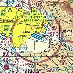
| Sectional chart |
|---|
|
CAUTION: Diagram may not be current
 Download PDF
of official airport diagram from the FAA
| Airport distance calculator |
|---|
|
|
| Sunrise and sunset |
|---|
|
Times for 12-Aug-2025
| | Local
(UTC-6) | | Zulu
(UTC) |
|---|
| Morning civil twilight | | 06:16 | | 12:16 |
| Sunrise | | 06:47 | | 12:47 |
| Sunset | | 20:52 | | 02:52 |
| Evening civil twilight | | 21:24 | | 03:24 |
|
| Current date and time |
|---|
| Zulu (UTC) | 12-Aug-2025 20:47:04 |
|---|
| Local (UTC-6) | 12-Aug-2025 14:47:04 |
|---|
|
| METAR |
|---|
| KBOI | 121953Z 25004KT 10SM CLR 36/07 A2996 RMK AO2 SLP109 T03560067
|
KMAN
13nm W | 122035Z AUTO 05003KT 6SM HZ CLR 36/13 A2993 RMK A01
|
KEUL
17nm W | 121956Z AUTO VRB03KT 10SM CLR 34/11 A2994 RMK AO2 SLP113 T03390111 PNO $
|
|
| TAF |
|---|
| KBOI | 121721Z 1218/1318 VRB06KT P6SM SKC FM122100 33009KT P6SM FEW120 FM130200 VRB06KT P6SM SCT120 FM131600 32009KT P6SM SKC
|
KEUL
17nm W | 121721Z 1218/1318 VRB05KT P6SM SKC FM122000 35006KT P6SM FEW120 FM130100 VRB04KT P6SM SCT120 FM131600 32009KT P6SM SKC
|
|
| NOTAMs |
|---|
NOTAMs are issued by the DoD/FAA and will open in a separate window not controlled by AirNav.
|
|


