FAA INFORMATION EFFECTIVE 02 OCTOBER 2025
Location
| FAA Identifier: | CDW |
| Lat/Long: | 40-52-30.8090N 074-16-52.8610W
40-52.513483N 074-16.881017W
40.8752247,-74.2813503
(estimated) |
| Elevation: | 172.3 ft. / 52.5 m (surveyed) |
| Variation: | 13W (1985) |
| From city: | 2 miles N of CALDWELL, NJ |
| Time zone: | UTC -4 (UTC -5 during Standard Time) |
| Zip code: | 07004 |
Airport Operations
| Airport use: | Open to the public |
| Activation date: | 02/1938 |
| Control tower: | yes |
| ARTCC: | NEW YORK CENTER |
| FSS: | MILLVILLE FLIGHT SERVICE STATION |
| NOTAMs facility: | CDW (NOTAM-D service available) |
| Attendance: | 0700-2300 |
| Pattern altitude: | TPA FOR LARGE & TURBOJET ACFT 1527 FT AGL; TPA FOR LIGHT ACFT 1027 FT AGL. |
| Wind indicator: | lighted |
| Segmented circle: | no |
| Lights: | WHEN ATCT CLSD, PAPI RWY 22; HIRL RWY 04/22; MIRL RWY 10/28 OPR CONSLY. HIRL RWY 04/22; MIRL RWY 10/28 PRESET TO LOW INTST. TO INCRS INTST AND ACTVT REIL RWY 22 - CTAF. |
| Beacon: | white-green (lighted land airport)
AIRPORT BEACON LOCATED ON TOP OF CONTROL TOWER. Operates sunset to sunrise. |
| Landing fee: | yes |
Airport Communications
| CTAF: | 119.8 |
| UNICOM: | 122.95 |
| ATIS: | 135.5 |
| WX ASOS: | 135.5 (973-575-4417) |
| CALDWELL GROUND: | 121.9 [0700-2300] |
| CALDWELL TOWER: | 119.8 [0700-2300] |
| NEWARK APPROACH: | 127.6 |
| NEWARK DEPARTURE: | 119.2 |
| CLEARANCE DELIVERY: | 121.1 |
| JAIKE STAR: | 132.8 |
| WILKES-BARRE STAR: | 127.6 |
| WX AWOS-3 at MMU (8 nm SW): | PHONE 973-290-0135 |
| WX ASOS at TEB (10 nm E): | PHONE 201-473-3130 |
| WX ASOS at EWR (12 nm SE): | PHONE 862-381-4743 |
| WX AWOS-3 at LDJ (16 nm S): | 124.025 (908-862-7383) |
| WX AWOS-3PT at JRB (16 nm SE): | 128.175 (212-425-1534) |
| WX ASOS at LGA (19 nm E): | PHONE 929-229-1994 |
- FREQ 121.5 NOT AVAILABLE.
Nearby radio navigation aids
| VOR radial/distance | | VOR name | | Freq | | Var |
|---|
| TEBr290/10.1 | | TETERBORO VOR/DME | | 108.40 | | 11W |
| SAXr146/16.4 | | SPARTA VORTAC | | 115.70 | | 11W |
| LGAr298/19.5 | | LA GUARDIA VOR/DME | | 113.10 | | 12W |
| CRIr323/23.6 | | CANARSIE VOR/DME | | 112.30 | | 11W |
| BWZr090/25.0 | | BROADWAY VOR/DME | | 114.20 | | 11W |
| SBJr060/27.3 | | SOLBERG VOR/DME | | 112.90 | | 10W |
| JFKr314/27.4 | | KENNEDY VOR/DME | | 115.90 | | 12W |
| STWr116/27.6 | | STILLWATER VOR/DME | | 109.60 | | 11W |
| COLr002/34.3 | | COLTS NECK VOR/DME | | 115.40 | | 11W |
| HUOr167/35.0 | | HUGUENOT VOR/DME | | 116.10 | | 11W |
| CMKr245/39.9 | | CARMEL VOR/DME | | 116.60 | | 12W |
Airport Services
| Fuel available: | 100LL JET-A |
| Parking: | hangars and tiedowns |
| Airframe service: | MAJOR |
| Powerplant service: | MAJOR |
| Bottled oxygen: | LOW |
| Bulk oxygen: | NONE |
Runway Information
Runway 4/22
| Dimensions: | 4552 x 80 ft. / 1387 x 24 m |
| Surface: | asphalt/grooved, in good condition |
| Weight bearing capacity: | |
| Runway edge lights: | high intensity |
| RUNWAY 4 | | RUNWAY 22 |
| Latitude: | 40-52.065605N | | 40-52.717402N |
| Longitude: | 074-17.180260W | | 074-16.692303W |
| Elevation: | 172.0 ft. | | 172.1 ft. |
| Traffic pattern: | left | | right |
| Runway heading: | 043 magnetic, 030 true | | 223 magnetic, 210 true |
| Displaced threshold: | 375 ft. | | 135 ft. |
| Declared distances: | TORA:4552 TODA:4552 ASDA:4351 LDA:3977 | | TORA:4552 TODA:4552 ASDA:4436 LDA:4042 |
| Markings: | nonprecision, in good condition | | nonprecision, in good condition |
| Visual slope indicator: | | | 4-light PAPI on right (3.00 degrees glide path)
RY 22 PAPI UNUSABLE BYD 5 DEGREES RIGHT OF CENTERLINE DUE TO OBSTRUCTION. |
| Runway end identifier lights: | no | | yes |
| Touchdown point: | yes, no lights | | yes, no lights |
| Instrument approach: | | | LOCALIZER |
| Obstructions: | 45 ft. tree, 220 ft. from runway, 137 ft. left of centerline
APCH RATIO 13:1 TO DSPLCD THLD. | | 90 ft. trees, 400 ft. from runway, 245 ft. both sides of centerline, 2:1 slope to clear
6 FT FENCE, 200 FT FM RY END, ACROSS CNTRLN. |
Runway 10/28
| Dimensions: | 3719 x 75 ft. / 1134 x 23 m |
| Surface: | asphalt, in good condition |
| Weight bearing capacity: | |
| Runway edge lights: | medium intensity |
| RUNWAY 10 | | RUNWAY 28 |
| Latitude: | 40-52.626308N | | 40-52.699297N |
| Longitude: | 074-17.213872W | | 074-16.412762W |
| Elevation: | 168.4 ft. | | 172.1 ft. |
| Traffic pattern: | left | | right |
| Runway heading: | 096 magnetic, 083 true | | 276 magnetic, 263 true |
| Displaced threshold: | 344 ft. | | 550 ft. |
| Declared distances: | TORA:3719 TODA:3719 ASDA:3519 LDA:2822 | | TORA:3719 TODA:3719 ASDA:3438 LDA:2822 |
| Markings: | basic, in good condition | | basic, in good condition |
| Runway end identifier lights: | no | | no |
| Touchdown point: | yes, no lights | | yes, no lights |
| Obstructions: | 39 ft. tree, 264 ft. from runway, 1:1 slope to clear
RY 10 APCH SLOPE 11:1 TO DSPLCD THLD. | | 46 ft. tree, 423 ft. from runway, 123 ft. left of centerline, 4:1 slope to clear
6 FT FENCE, 195 FT FM RY END, 120 FT LT OF CNTRLN. |
Airport Ownership and Management from official FAA records
| Ownership: | Publicly-owned |
| Owner: | ESSEX COUNTY IMPROVEMENT AUTHORITY
27 WRIGHT WAY
FAIRFIELD, NJ 07004
Phone 973-575-0952 |
| Manager: | JOE CALI
27 WRIGHT WAY
FAIRFIELD, NJ 07004
Phone 973-227-4567 |
Additional Remarks
| - | DEER & BIRDS ON & INVOF ARPT. |
| - | NON-STANDARD TRAFFIC PATTERNS FOR RWY 04 PROHIBITED DUE TO NOISE SENSITIVE AREA SOUTHWEST OF THE AIRPORT. |
| - | FOR CD WHEN ATCT IS CLSD CTC NEWARK APCH AT 800-645-3206. |
| - | ROTOCRAFT: IF PSBL, CROSS THE ARPT BDRY AT OR ABV 700 FT MSL. |
| - | ENG RUN-UPS ON TWY N AT AER 28 SHD BE CONDUCTED TO LMT EFCT TO ACFT PARKED ON RN RAMP. |
| - | LCL OPNS SUSPENDED FROM 2300-0700 MON THRU SAT 2300 SAT UNTIL 1000 SUN. |
| - | FIXED WING VFR ACFT DEP: RWY 4 - FLY RWY HDG FOR 1 MI, THEN TURN CROSSWIND IF REMAINING IN THE TFC PAT. IF DEPARTING THE TFC PAT, CONT ON RWY HDG TIL REACHING TFC PAT ALT. |
| - | FIXED WING VFR ACFT DEP: RWY 10 - FLY HDG 080 DEG AT RWY DEP END. UPON REACHING 900 FT MSL, TURN CROSSWIND IF REMAINING IN THE TFC PAT; IF DEPARTING THE TFC PAT, CONT ON HDG 080 DEG TIL REACHING TFC PAT ALT. |
| - | FIXED WING VFR ACFT DEP: RWY 22 - FLY RWY HDG TIL REACHING 900 FT MSL, THEN TURN CROSSWIND IF REMAINING IN THE TFC PAT. IF DEPARTING THE TFC PAT, CONT ON RWY HDG TIL REACHING TFC PAT ALT. |
| - | FIXED WING VFR ACFT DEP: RWY 28 - FLY RWY HDG FOR 1 MI THEN TURN CROSSWIND IF REMAINING IN THE TFC PAT. IF DEPARTING THE TFC PAT, CONT ON RWY HDG TIL READHING TFC PAT ALT. |
| - | PILOTS BE ALERT -- THE MORRISTOWN ILS & GPS RWY 23 APPROACHES TRANSIT ESSEX CO ARPT CLASS D ASP. TFC PASSES TWO MI WEST OF THE ARPT DESCENDING THRU 2000 FT MSL. |
Instrument Procedures
NOTE: All procedures below are presented as PDF files. If you need a reader for these files, you should download the free Adobe Reader.NOT FOR NAVIGATION. Please procure official charts for flight.
FAA instrument procedures published for use from 02 October 2025 at 0901Z to 30 October 2025 at 0900z.
STARs - Standard Terminal Arrivals |
|---|
| JAIKE FOUR (RNAV) | |
2 pages:
[1] [2] (364KB) |
| MAZIE THREE (RNAV) | |
download (199KB) |
| WILKES-BARRE FIVE | |
download (181KB) |
IAPs - Instrument Approach Procedures |
|---|
| RNAV (GPS) RWY 04 | |
download (232KB) |
| RNAV (GPS) RWY 10 | |
download (227KB) |
| RNAV (GPS) RWY 22 | |
download (221KB) |
| LOC RWY 22 | |
download (296KB) |
| NOTE: Special Alternate Minimums apply | |
download (143KB) |
| NOTE: Special Take-Off Minimums/Departure Procedures apply | |
download (150KB) |
Other nearby airports with instrument procedures:
N07 - Lincoln Park Airport (5 nm N)
KMMU - Morristown Municipal Airport (8 nm SW)
KTEB - Teterboro Airport (10 nm E)
KEWR - Newark Liberty International Airport (12 nm SE)
KJRA - West 30th St Heliport (14 nm SE)
4N1 - Greenwood Lake Airport (15 nm N)
KLDJ - Linden Airport (16 nm S)
6N5 - East 34th Street Heliport (16 nm SE)
KJRB - Downtown Manhattan/Wall Street Heliport (16 nm SE)
KLGA - LaGuardia Airport (19 nm E)
|
|

Road maps at:
MapQuest
Bing
Google
| Aerial photo |
|---|
WARNING: Photo may not be current or correct
 Photo by Joshua Weinstein
Photo taken 14-Oct-2018
looking east.
Photo by Joshua Weinstein
Photo taken 14-Oct-2018
looking east.
Do you have a better or more recent aerial photo of Essex County Airport that you would like to share? If so, please send us your photo.
|
| Sectional chart |
|---|
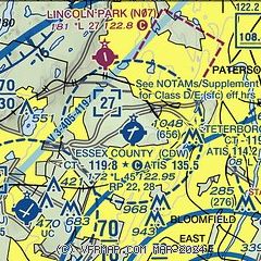
|
CAUTION: Diagram may not be current
 Download PDF
of official airport diagram from the FAA
| Airport distance calculator |
|---|
|
|
| Sunrise and sunset |
|---|
|
Times for 16-Oct-2025
| | Local
(UTC-4) | | Zulu
(UTC) |
|---|
| Morning civil twilight | | 06:43 | | 10:43 |
| Sunrise | | 07:11 | | 11:11 |
| Sunset | | 18:15 | | 22:15 |
| Evening civil twilight | | 18:43 | | 22:43 |
|
| Current date and time |
|---|
| Zulu (UTC) | 16-Oct-2025 04:57:13 |
|---|
| Local (UTC-4) | 16-Oct-2025 00:57:13 |
|---|
|
| METAR |
|---|
| KCDW | 160453Z AUTO VRB04KT 10SM CLR 11/01 A2999 RMK AO2 SLP159 T01060011 402060106 $
|
KMMU
8nm SW | 160435Z AUTO 31006KT 10SM CLR 10/01 A2998 RMK AO2
|
KTEB
11nm E | 160451Z 33005KT 10SM CLR 09/02 A2997 RMK AO2 SLP148 T00940017 402110094 $
|
KEWR
13nm SE | 160451Z 34011KT 10SM SCT170 12/01 A2998 RMK AO2 SLP151 T01220006 402220122
|
KNYC
15nm E | 160451Z AUTO VRB04KT 10SM CLR 12/02 A3000 RMK AO2 SLP149 T01170017 402000117
|
KLDJ
16nm S | 160455Z AUTO 34007G15KT 10SM CLR 12/01 A2998 RMK AO2 T01150005
|
KJRB
16nm SE | 160356Z AUTO VRB03KT 10SM CLR 14/06 A2998 RMK AO2 SLP153 T01390056 402280139
|
KLGA
19nm E | 160451Z 01011KT 10SM BKN170 12/01 A2996 RMK AO2 SLP146 T01170011 402060117
|
|
| TAF |
|---|
KTEB
11nm E | 160232Z 1603/1706 35009KT P6SM SCT150 FM161300 34012G20KT P6SM SKC FM161700 34016G25KT P6SM SKC FM170000 34010G20KT P6SM SKC
|
KEWR
13nm SE | 160232Z 1603/1706 34011KT P6SM SCT120 TEMPO 1603/1606 34013G20KT FM161300 33013G21KT P6SM SKC FM161700 34018G27KT P6SM SKC FM170200 34014G22KT P6SM SKC
|
KLGA
19nm E | 160232Z 1603/1706 35012KT P6SM SCT120 TEMPO 1603/1606 35014G20KT FM161300 34014G23KT P6SM SKC FM161600 34019G28KT P6SM SKC FM170300 34015G23KT P6SM SKC
|
|
| NOTAMs |
|---|
NOTAMs are issued by the DoD/FAA and will open in a separate window not controlled by AirNav.
|
|


