FAA INFORMATION EFFECTIVE 19 FEBRUARY 2026
Location
| FAA Identifier: | 0C0 |
| Lat/Long: | 42-24-08.9000N 088-37-56.6000W
42-24.148333N 088-37.943333W
42.4024722,-88.6323889
(estimated) |
| Elevation: | 913.2 ft. / 278.3 m (surveyed) |
| Variation: | 00W (1985) |
| From city: | 1 mile SW of HARVARD, IL |
| Time zone: | UTC -6 (UTC -5 during Daylight Saving Time) |
| Zip code: | 60033 |
Airport Operations
| Airport use: | Open to the public |
| Activation date: | 11/1945 |
| Control tower: | no |
| ARTCC: | CHICAGO CENTER |
| FSS: | KANKAKEE FLIGHT SERVICE STATION |
| NOTAMs facility: | IKK (NOTAM-D service available) |
| Attendance: | 0800-1700 |
| Pattern altitude: | 1513.2 ft. MSL |
| Wind indicator: | lighted |
| Segmented circle: | no |
| Lights: | SS-SR |
Airport Communications
Nearby radio navigation aids
| VOR radial/distance | | VOR name | | Freq | | Var |
|---|
| JVLr111/22.9 | | JANESVILLE VOR/DME | | 114.30 | | 03E |
| OBKr292/32.1 | | NORTHBROOK VOR/DME | | 113.00 | | 02W |
| DPAr336/33.2 | | DUPAGE VOR/DME | | 114.55 | | 02E |
Airport Services
| Fuel available: | 100LL |
| Parking: | hangars and tiedowns |
| Airframe service: | MAJOR |
| Powerplant service: | MAJOR |
| Bottled oxygen: | NONE |
| Bulk oxygen: | NONE |
Runway Information
Runway 9/27
| Dimensions: | 3589 x 105 ft. / 1094 x 32 m |
| Surface: | turf, in fair condition |
| Runway edge markings: | DSPLCD THLD MKD WITH WHITE TIRES. |
| RUNWAY 9 | | RUNWAY 27 |
| Latitude: | 42-24.028165N | | 42-24.030960N |
| Longitude: | 088-38.471987W | | 088-37.674715W |
| Elevation: | 898.8 ft. | | 912.6 ft. |
| Traffic pattern: | left | | left |
| Runway heading: | 090 magnetic, 090 true | | 270 magnetic, 270 true |
| Displaced threshold: | 300 ft. | | no |
| Markings: | none | | none |
| Runway end identifier lights: | no | | no |
| Obstructions: | 44 ft. tree, 405 ft. from runway, 117 ft. right of centerline, 9:1 slope to clear
APCH RATIO 23:1 TO DSPLCD THLD. | | tree, 20:1 slope to clear |
Runway 14/32
| Dimensions: | 2633 x 100 ft. / 803 x 30 m |
| Surface: | turf, in fair condition |
| Runway edge markings: | DSPLCD THLD MKD WITH WHITE TIRES. |
| RUNWAY 14 | | RUNWAY 32 |
| Latitude: | 42-24.431042N | | 42-24.039162N |
| Longitude: | 088-37.943762W | | 088-37.693768W |
| Elevation: | 911.7 ft. | | 911.9 ft. |
| Traffic pattern: | left | | left |
| Runway heading: | 155 magnetic, 155 true | | 335 magnetic, 335 true |
| Displaced threshold: | 681 ft. | | no |
| Markings: | none | | none |
| Runway end identifier lights: | no | | no |
| Obstructions: | 42 ft. tree, 542 ft. from runway, 25 ft. left of centerline, 13:1 slope to clear
SLOPE 24:1 TO DSPLCD THLD. | | none |
Runway 18/36
| Dimensions: | 2577 x 120 ft. / 785 x 37 m |
| Surface: | turf, in fair condition |
| Runway edge lights: | non-standard
RWY 18/36 NSTD LIRL; NSTD SPACING & NON-FRANGIBLE. RY 18/36 2,272' LIGHTED. |
| Runway edge markings: | RY 18 DSPLCD THLD MKD WITH WHITE TIRES AND ORANGE & WHITE BARRELS. |
| RUNWAY 18 | | RUNWAY 36 |
| Latitude: | 42-24.438567N | | 42-24.014260N |
| Longitude: | 088-37.889175W | | 088-37.888948W |
| Elevation: | 913.2 ft. | | 908.6 ft. |
| Traffic pattern: | left | | left |
| Runway heading: | 180 magnetic, 180 true | | 000 magnetic, 360 true |
| Displaced threshold: | 305 ft. | | no |
| Markings: | none | | none |
| Runway end identifier lights: | no | | no |
| Obstructions: | 15 ft. road, 30 ft. from runway, 2:1 slope to clear
APCH RATIO 22:1 TO DSPLCD THLD. | | none |
Airport Ownership and Management from official FAA records
| Ownership: | Privately-owned |
| Owner: | DACY AIRPORT LLC.
22211 AIRPORT RD, PO BOX 225
HARVARD, IL 60033
Phone 815-943-9876 |
| Manager: | DAVE DACY
22211 AIRPORT RD, PO BOX 225
HARVARD, IL 60033
Phone 815-943-9876 |
Additional Remarks
| - | FOR CD CTC CHICAGO ARTCC AT 630-906-8921. |
Instrument Procedures
There are no published instrument procedures at 0C0.
Some nearby airports with instrument procedures:
C77 - Poplar Grove Airport (10 nm SW)
10C - Galt Field Airport (11 nm E)
44C - Beloit Airport (16 nm W)
3CK - Lake in the Hills Airport (18 nm SE)
KJVL - Southern Wisconsin Regional Airport (22 nm NW)
|
|

Road maps at:
MapQuest
Bing
Google
| Aerial photo |
|---|
WARNING: Photo may not be current or correct

Do you have a better or more recent aerial photo of Dacy Airport that you would like to share? If so, please send us your photo.
|
| Sectional chart |
|---|
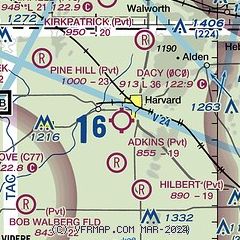
|
| Airport distance calculator |
|---|
|
|
| Sunrise and sunset |
|---|
|
Times for 19-Mar-2026
| | Local
(UTC-5) | | Zulu
(UTC) |
|---|
| Morning civil twilight | | 06:33 | | 11:33 |
| Sunrise | | 07:01 | | 12:01 |
| Sunset | | 19:04 | | 00:04 |
| Evening civil twilight | | 19:32 | | 00:32 |
|
| Current date and time |
|---|
| Zulu (UTC) | 19-Mar-2026 06:36:51 |
|---|
| Local (UTC-5) | 19-Mar-2026 01:36:51 |
|---|
|
| METAR |
|---|
KJVL
21nm NW | 190615Z AUTO 14004KT 10SM BKN100 BKN120 01/M01 A3002 RMK AO2
|
KBUU
22nm NE | 190615Z AUTO 19005KT 10SM SCT120 00/M02 A3002 RMK AO2 T00001025 PWINO
|
KRFD
24nm SW | 190554Z 00000KT 10SM OVC120 01/M02 A3006 RMK AO2 SLP185 4/001 T00061017 10028 20000 400441061 58002 $
|
K57C
26nm NE | 190615Z AUTO 23003KT 10SM SCT095 OVC110 01/M03 A3003 RMK AO2 T00101031
|
KDKB
28nm S | 190615Z AUTO 00000KT 10SM SCT120 01/M01 A3005 RMK AO2 T00111015
|
KENW
33nm E | 190153Z 23004KT 10SM OVC025 02/M03 A3006
|
KDPA
34nm SE | 190552Z 02004KT 10SM CLR 01/M01 A3004 RMK AO2 SLP179 6//// T00111006 10044 20006 400671050 56004 PNO $
|
KUGN
34nm E | 190551Z AUTO 25003KT 10SM BKN120 01/M02 A3004 RMK AO2 SLP183 T00111022 10033 21006 400501056 55002
|
K06C
34nm SE | 190615Z AUTO 00000KT 10SM SCT120 02/M01 A3004 RMK AO2 T00221013
|
KRPJ
37nm SW | 190615Z AUTO 00000KT 10SM SCT120 01/M01 A3004 RMK AO2 T00101010 TSNO
|
|
| TAF |
|---|
KJVL
21nm NW | 190520Z 1906/2006 VRB02KT P6SM OVC060 FM191400 VRB03KT 6SM BR BKN035 FM191800 VRB04KT P6SM BKN100 FM200300 VRB04KT P6SM BKN035
|
KRFD
24nm SW | 190526Z 1906/2006 VRB03KT P6SM BKN100 OVC150 FM191500 12007KT P6SM SCT050 BKN250
|
|
| NOTAMs |
|---|
NOTAMs are issued by the DoD/FAA and will open in a separate window not controlled by AirNav.
|
|

