FAA INFORMATION EFFECTIVE 19 FEBRUARY 2026
Location
| FAA Identifier: | SDL |
| Lat/Long: | 33-37-22.4000N 111-54-37.9000W
33-37.373333N 111-54.631667W
33.6228889,-111.9105278
(estimated) |
| Elevation: | 1510.1 ft. / 460.3 m (surveyed) |
| Variation: | 12E (1990) |
| From city: | 9 miles N of SCOTTSDALE, AZ |
| Time zone: | UTC -7 (year round; does not observe DST) |
| Zip code: | 85260 |
Airport Operations
| Airport use: | Open to the public |
| Activation date: | 03/1943 |
| Control tower: | yes |
| ARTCC: | ALBUQUERQUE CENTER |
| FSS: | PRESCOTT FLIGHT SERVICE STATION |
| NOTAMs facility: | SDL (NOTAM-D service available) |
| Attendance: | CONTINUOUS |
| Pattern altitude: | TPA PROP 990 FT; JET 1490 FT; HELICOPTER 490 FT AGL. |
| Wind indicator: | lighted |
| Segmented circle: | yes |
| Lights: | WHEN ATCT CLSD ACTVT REIL RWY 03 & 21; PAPI RWY 03 & 21; MIRL RWY 03/21 - CTAF. |
| Beacon: | white-green (lighted land airport)
Operates sunset to sunrise. |
| Landing fee: | no, TSNT FEE FOR ACFT 12500 LB OR GREATER BASED ON MAX CERT RAMP WEIGHT; TSNT OVERNIGHT PARKING FEE. |
| International operations: | CUSTOMS SVC AVBL 1600Z TO 0200Z; USER FEE MUST BE
PREPAID ONLINE PRIOR TO ARR. |
Airport Communications
| CTAF: | 119.9 |
| ATIS: | 118.6 |
| WX ASOS: | PHONE 480-483-3049 |
| SCOTTSDALE GROUND: | 121.6 [0600-2100] |
| SCOTTSDALE TOWER: | 119.9 [0600-2100] |
| PHOENIX APPROACH: | 120.7 |
| PHOENIX DEPARTURE: | 120.7 |
| CLEARANCE DELIVERY: | 124.8 |
| BLYTHE STAR: | 124.1 |
| DSERT STAR: | 120.7 |
| HEL OPS: | 125.5 |
| SUNSS STAR: | 124.1 |
| WX ASOS at DVT (9 nm NW): | 126.5 (623-587-7764) |
| WX AWOS-1 at 18AZ (12 nm N): | 125.625 (480-488-7882) |
| WX ASOS at PHX (12 nm SW): | PHONE 602-551-6092 |
| WX ASOS at FFZ (13 nm SE): | PHONE 480-641-4111 |
- EMERG FREQ 121.5 NOT AVBL AT ATCT.
- COMMUNICATIONS PRVDD BY PRESCOTT RADIO ON FREQ 122.2 (PHOENIX RCO).
Nearby radio navigation aids
| VOR radial/distance | | VOR name | | Freq | | Var |
|---|
| PXRr003/11.8 | | PHOENIX VORTAC | | 115.60 | | 12E |
| IWAr313/23.2 | | WILLIE VORTAC | | 113.30 | | 13E |
Airport Services
| Fuel available: | 100LL JET-A1+ |
| Parking: | hangars and tiedowns |
| Airframe service: | MAJOR |
| Powerplant service: | MAJOR |
| Bottled oxygen: | HIGH/LOW |
| Bulk oxygen: | HIGH/LOW |
Runway Information
Runway 3/21
| Dimensions: | 8249 x 100 ft. / 2514 x 30 m
150 FT BLAST PAD BOTH ENDS. |
| Surface: | asphalt, in good condition |
| Weight bearing capacity: | | Single wheel: | 45.0 | | Double wheel: | 75.0, CERT MAX TKOF WGT 75001 - 100000 LB OPRG ABV 75000 LB PPR - 480-312-8478. |
|
| Runway edge lights: | medium intensity |
| Operational restrictions: | MIDFIELD DEP & STOP & GO LNDG NA. TGL NA 2130-0600. RWY 03 CALM WIND RWY. |
| RUNWAY 3 | | RUNWAY 21 |
| Latitude: | 33-36.883528N | | 33-37.861970N |
| Longitude: | 111-55.196413W | | 111-54.067320W |
| Elevation: | 1444.2 ft. | | 1510.1 ft. |
| Traffic pattern: | left | | right |
| Runway heading: | 032 magnetic, 044 true | | 212 magnetic, 224 true |
| Displaced threshold: | 740 ft. | | 400 ft. |
| Declared distances: | TORA:8249 TODA:8249 ASDA:7849 LDA:7110 | | TORA:8249 TODA:8249 ASDA:8069 LDA:7669 |
| Markings: | nonprecision, in good condition | | nonprecision, in good condition |
| Visual slope indicator: | 2-light PAPI on left (4.00 degrees glide path) | | 2-light PAPI on left (4.00 degrees glide path) |
| Runway end identifier lights: | yes | | yes |
| Touchdown point: | yes, no lights | | yes, no lights |
| Obstructions: | 58 ft. tree, 1695 ft. from runway, 390 ft. right of centerline, 25:1 slope to clear
APCH SLOPE 50:1 AT DTHR. | | 25 ft. hill, 850 ft. from runway, 375 ft. right of centerline, 26:1 slope to clear
APCH SLOPE 39:1 AT DTHR. |
Airport Ownership and Management from official FAA records
| Ownership: | Publicly-owned |
| Owner: | CITY OF SCOTTSDALE
3939 CIVIC CENTER PLAZA
SCOTTSDALE, AZ 85251
Phone 480-312-2321 |
| Manager: | RICK WIELEBSKI
15000 N AIRPORT DR, SUITE 100
SCOTTSDALE, AZ 85260
Phone 480-312-7735 |
Additional Remarks
| - | MIL ARR 24 HR PPR - 480-312-8478. |
| - | VOLUNTARY NOISE ABATEMENT CURFEW 2200-0600; NOISE SENSITIVE AREA ALL QUADS; NOISE ABATEMENT - 480-312-8478. |
| - | WILDLIFE INVOF RWY. |
| - | FOR CD WHEN ATCT CLSD, CTC PHOENIX APCH AT 602-306-2565. |
| - | MAINT RUNUP NA 2200-0700. |
Instrument Procedures
NOTE: All procedures below are presented as PDF files. If you need a reader for these files, you should download the free Adobe Reader.NOT FOR NAVIGATION. Please procure official charts for flight.
FAA instrument procedures published for use from 19 February 2026 at 0901Z to 19 March 2026 at 0900Z.
STARs - Standard Terminal Arrivals |
|---|
| ARLIN FOUR | |
download (286KB) |
| BLYTHE FIVE | |
download (256KB) |
| DSERT TWO (RNAV) | |
2 pages:
[1] [2] (299KB) |
| SUNSS EIGHT | |
download (237KB) |
IAPs - Instrument Approach Procedures |
|---|
| RNAV (RNP) RWY 21 | |
download (279KB) |
| RNAV (RNP) Y RWY 03 | |
download (333KB) |
| RNAV (RNP) Z RWY 03 | |
download (256KB) |
| RNAV (GPS)-D | |
download (298KB) |
| RNAV (GPS)-E | |
download (204KB) |
| VOR/DME-A | |
download (224KB) |
| NOTE: Special Alternate Minimums apply | |
download (120KB) |
Departure Procedures |
|---|
| BNYRD SIX (RNAV) | |
download (187KB) |
| FTHLS SIX (RNAV) | |
download (241KB) |
| IZZZO EIGHT (RNAV) | |
download (231KB) |
| JONHH TWO | |
2 pages:
[1] [2] (381KB) |
| JUDTH SEVEN (RNAV) | |
download (184KB) |
| KATMN SIX (RNAV) | |
download (187KB) |
| LALUZ SIX (RNAV) | |
download (248KB) |
| MAYSA SEVEN (RNAV) | |
download (185KB) |
| SCOTTSDALE SEVEN | |
2 pages:
[1] [2] (535KB) |
| SNOBL SIX (RNAV) | |
download (248KB) |
| YOTES SIX (RNAV) | |
download (213KB) |
|
|---|
| MARICOPA ONE (OBSTACLE) | |
download (300KB) |
| NOTE: Special Take-Off Minimums/Departure Procedures apply | |
download (202KB) |
Other nearby airports with instrument procedures:
KDVT - Phoenix Deer Valley Airport (9 nm NW)
KPHX - Phoenix Sky Harbor International Airport (12 nm SW)
KFFZ - Falcon Field Airport (13 nm SE)
P19 - Stellar Airpark (19 nm S)
KGEU - Glendale Regional Airport (20 nm W)
|
|

Road maps at:
MapQuest
Bing
Google
| Aerial photo |
|---|
WARNING: Photo may not be current or correct
 Photo by Andreas Lauschke
Photo taken 07-Dec-2024
looking east.
Photo by Andreas Lauschke
Photo taken 07-Dec-2024
looking east.
Do you have a better or more recent aerial photo of Scottsdale Airport that you would like to share? If so, please send us your photo.
|
| Sectional chart |
|---|
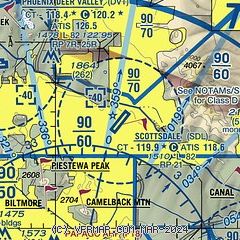
|
CAUTION: Diagram may not be current
 Download PDF
of official airport diagram from the FAA
| Airport distance calculator |
|---|
|
|
| Sunrise and sunset |
|---|
|
Times for 13-Mar-2026
| | Local
(UTC-7) | | Zulu
(UTC) |
|---|
| Morning civil twilight | | 06:17 | | 13:17 |
| Sunrise | | 06:42 | | 13:42 |
| Sunset | | 18:33 | | 01:33 |
| Evening civil twilight | | 18:58 | | 01:58 |
|
| Current date and time |
|---|
| Zulu (UTC) | 13-Mar-2026 15:11:47 |
|---|
| Local (UTC-7) | 13-Mar-2026 08:11:47 |
|---|
|
| METAR |
|---|
| KSDL | 131453Z 00000KT 10SM CLR 16/02 A3003 RMK AO2 SLP151 T01560017 51015
|
KDVT
9nm NW | 131453Z AUTO 00000KT 10SM CLR 18/M02 A3002 RMK AO2 SLP147 T01831022 51014
|
KPHX
13nm SW | 131451Z 14004KT 10SM FEW250 19/M01 A3000 RMK AO2 SLP145 T01891006 51015
|
KFFZ
13nm SE | 131454Z 05003KT 10SM CLR 19/M02 A3002 RMK AO2 SLP145 T01941017 51015
|
|
| TAF |
|---|
| KSDL | 131120Z 1312/1412 VRB03KT P6SM SKC FM132100 24005KT P6SM FEW250 FM140200 VRB03KT P6SM FEW200 SCT250
|
KDVT
9nm NW | 131120Z 1312/1412 04004KT P6SM SKC FM131600 VRB04KT P6SM SKC FM132100 25006KT P6SM FEW250 FM140400 04004KT P6SM FEW200 SCT250
|
KPHX
13nm SW | 131120Z 1312/1418 11005KT P6SM SKC FM131900 VRB04KT P6SM FEW250 FM132200 27006KT P6SM FEW250 FM140400 VRB04KT P6SM SCT250 FM140800 11005KT P6SM FEW200 SCT250
|
|
| NOTAMs |
|---|
NOTAMs are issued by the DoD/FAA and will open in a separate window not controlled by AirNav.
|
|
FBO, Fuel Providers, and Aircraft Ground Support |
|---|
| | 
Business Name | |
Contact | |
Services / Description | |
Fuel Prices | |
Comments | |
|---|
 |
|
ASRI 131.50
480-866-8270
[web site]
[email] |
|
Located in the heart of North Scottsdale with easy access to shopping, dining, entertainment and Arizona's iconic attractions. Jet Aviation Scottsdale offers state-of-the-art facilities including a modern 30,000 sq. ft hangar with tenant office space, passenger and crew lounges, award-winning concierge service, wireless internet access, refueling, complete line service, aircraft cleaning, and more.


|
|
 | | 100LL | Jet A | SAF | | FS | | $8.95 | | $7.50 | | $9.55 | | GUARANTEED |  | MEMBERS
ONLY
Discounts |
| |
|
|

1 read write
|
|
 |
|
ASRI 129.70
480-948-2400
toll-free 800-995-5387
[web site]
[email] |
|
Atlantic Aviation is your premier aviation service provider with more than 100 locations in North America, including Hawaii and the Caribbean. We provide standard ground services you'd expect, with a detailed focus on ensuring an unforgettable customer experience.

|
|
 | | 100LL | Jet A | | FS | | $9.35 | | $9.55 | | Updated 13-Mar-2026 |
|
|
1 read write
|
|
 |
|
ASRI 131.175
480-951-2525
[web site]
[email] |
|
Signature Aviation at Scottsdale Airport (SDL) provides safe, seamless private aviation access to Scottsdale, located in the Sonoran Desert near the McDowell Mountains, connecting travelers to the region's business centers, resorts, and vibrant arts district.
To request Scottsdale private aviation services or manage your visit, log into your Signature Vision account at
https://www.signatureaviation.com/services/signature-vision.

|
|
| | 100LL | Jet A | SAF | | FS | | $9.00 | | $9.05 | | $11.32 | | Updated 13-Mar-2026 |
|
|
write
|
|
Alternatives at nearby airports
IMPORTANT: Note that the FBOs below are NOT at KSDL but at other nearby airports. Do not expect services from these FBOs to be available at KSDL. |
 |
|
UNICOM 122.95
623-581-1444
toll-free 800-792-0952
[web site]
[email] |
|
At KDVT (Phoenix Deer Valley Airport), 9 miles WNW
Cutter Aviation at Deer Valley Airport (DVT) is only NINE miles from SDL with the same level of quality and service for LESS COST.
Is a nine mile difference worth the extra cost for fuel, fees & services at SDL? Additionally, with 2 large, parallel runways, DVT offers a less congested and less noise-sensitive arrival and departure. With fast and easy access to the I-17 and Loop 101 freeways, your destination may even be closer and a quicker drive from Cutter Aviation DVT!
Give Cutter Aviation DVT a try on your next trip to Scottsdale and save time and money!
|
|
| Located at KDVT |  | | 100LL | Jet A | | FS | | $8.38 | | $9.18 | | GUARANTEED | | MEMBERS
ONLY
Discounts |
| |
|
|

4 read write
|
|
 |
|
ASRI 129.875
480-988-7700
[web site]
[email]


|
|
At KIWA (Mesa Gateway Airport), 23 miles SE
Mesa Gateway Airport is your best aviation value when visiting the Phoenix Metropolitan area. Our three expansive runways (10,401; 10,201; 9,301 feet), close freeway access, and competitive pricing make a great alternative to other valley airports.
|
|
|
|
1 read write
|
|
 |
|
ASRI 132.00
602-273-3770
[web site]
[email] |
|
At KPHX (Phoenix Sky Harbor International Airport), 12 miles SSW
Jackson Jet Cente state-of-the-art-facility includes the largest arrival and departure canopy in the Southwest, keeping your aircraft in the shade and cool. Just a 15 minute drive will put you right in the heart of Old Town Scottsdale, or even shorter to Tempe or Downtown Phoenix.
|
|
| Located at KPHX |  | | 100LL | Jet A | | FS | | $7.60 | | $7.75 | | GUARANTEED | | MEMBERS
ONLY
Discounts |
| |
|
|
write
|
|
 |
|
ASRI 131.425
602-488-3878
[web site]
[email] |
|
At KFFZ (Falcon Field Airport), 13 miles SE
Cunningham Aviation is Arizona's newest full service FBO. We are located at Falcon Field (KFFZ) which is closer to Downtown Scottsdale and Downtown Phoenix than KSDL. We also have much quicker and easier access to freeways making your drive to your business appointment or sporting event even more convenient.
Cunningham Aviation offers aircraft ground handling and parking (ramp or tie-down) hangar leasing, car rental, lav service, GPU, and oxygen. Full Service Jet A and 100LL available 24/7 and self-serve 100LL.
|
|
|
|
11 read write
|
|

|
| |
Aviation Businesses, Services, and Facilities |
|---|
| |
Business Name | |
Contact | |
Services / Description | |
Distance | |
Comments | |
|---|
|
|
|
480-248-8500
772-539-0420
[web site]
[email] |
|
Legacy Flight Training is a Piper factory authorized flight training center for Piper owners offering initial & recurrent training in our simulators and/or in-aircraft training for M500, Meridian, Mirage, Matrix Malibu and we are the exclusive training provider for the M600.
|
|
on airport |
|
write
|
|
|
|
|
480-665-6406
[web site]
[email]

|
|
Aircraft maintenance

|
|
on airport |
|
write
|
|
|
|
|
toll-free 844-407-8776
702-888-0893
[web site]
[email]
|
|
Aircraft maintenance, Avionics sales and service
|
|
300 miles |
|
write
|
|
| |
Would you like to see your business listed on this page? |
|---|
| | If your business provides an interesting product or service to pilots, flight crews, aircraft, or users of the Scottsdale Airport, you should consider listing it here. To start the listing process, click on the button below

|


