FAA INFORMATION EFFECTIVE 22 JANUARY 2026
Location
| FAA Identifier: | CHN |
| Lat/Long: | 27-30-53.7000N 081-52-49.7000W
27-30.895000N 081-52.828333W
27.5149167,-81.8804722
(estimated) |
| Elevation: | 107.8 ft. / 32.9 m (surveyed) |
| Variation: | 04W (2000) |
| From city: | 5 miles SW of WAUCHULA, FL |
| Time zone: | UTC -5 (UTC -4 during Daylight Saving Time) |
| Zip code: | 33873 |
Airport Operations
| Airport use: | Open to the public |
| Activation date: | 11/1983 |
| Control tower: | no |
| ARTCC: | MIAMI CENTER |
| FSS: | SAINT PETERSBURG FLIGHT SERVICE STATION |
| NOTAMs facility: | PIE (NOTAM-D service available) |
| Attendance: | UNATTND |
| Wind indicator: | lighted |
| Segmented circle: | yes |
| Lights: | ACTVT REIL RWY 18 & 36; MIRL RWY 18/36 - CTAF. |
| Beacon: | white-green (lighted land airport)
Operates sunset to sunrise. |
Airport Communications
| CTAF: | 122.9 |
| WX AWOS-2: | 118.35 (863-767-0559) |
| WX AWOS-3 at AVO (19 nm E): | 118.725 (863-453-4223) |
- APCH/DEP SVC PRVDD BY MIAMI ARTCC ON FREQS 134.55/257.7 (AVON PARK RCAG).
Nearby radio navigation aids
| VOR radial/distance | | VOR name | | Freq | | Var |
|---|
| LALr165/29.2 | | LAKELAND VORTAC | | 116.00 | | 01E |
| SRQr085/36.9 | | SARASOTA VOR/DME | | 117.00 | | 05W |
Airport Services
| Fuel available: | 100LL
100LL:FUEL 24 HR CREDIT CARD SVC AVBL. |
| Parking: | tiedowns |
| Airframe service: | MINOR |
| Powerplant service: | MINOR |
| Bottled oxygen: | NONE |
| Bulk oxygen: | NONE |
Runway Information
Runway 18/36
| Dimensions: | 4005 x 75 ft. / 1221 x 23 m |
| Surface: | asphalt, in excellent condition |
| Weight bearing capacity: | | PCN 7 /F/B/Y/T | | Single wheel: | 24.0 | | Double wheel: | 39.0 |
|
| Runway edge lights: | medium intensity |
| RUNWAY 18 | | RUNWAY 36 |
| Latitude: | 27-31.224823N | | 27-30.563918N |
| Longitude: | 081-52.828178W | | 081-52.827343W |
| Elevation: | 99.3 ft. | | 103.3 ft. |
| Traffic pattern: | left | | left |
| Runway heading: | 184 magnetic, 180 true | | 004 magnetic, 360 true |
| Markings: | nonprecision, in fair condition | | nonprecision, in fair condition |
| Visual slope indicator: | 4-light PAPI on left (4.00 degrees glide path) | | 4-light PAPI on left (3.00 degrees glide path) |
| Runway end identifier lights: | yes | | yes |
| Touchdown point: | yes, no lights | | yes, no lights |
| Obstructions: | 24 ft. trees, 600 ft. from runway, 125 ft. left of centerline, 16:1 slope to clear | | 5 ft. brush, 205 ft. from runway, 225 ft. right of centerline, 1:1 slope to clear |
Airport Ownership and Management from official FAA records
| Ownership: | Publicly-owned |
| Owner: | CITY OF WAUCHULA
126 S 7TH AVE.
WAUCHULA, FL 33873
Phone 863-773-3131
CTC PERSON: OLIVIA MINSHEW |
| Manager: | WARD GRIMES
1202 MAURICE SONNY CLAVEL RD.
WAUCHULA, FL 33873
Phone 863-773-3115
AIRPORT PHYSICAL ADDRESS: 1202 MAURICE SONNY CLAVEL ROAD. |
Additional Remarks
| - | FOR CD CTC MIAMI ARTCC AT 305-716-1731. |
Instrument Procedures
NOTE: All procedures below are presented as PDF files. If you need a reader for these files, you should download the free Adobe Reader.NOT FOR NAVIGATION. Please procure official charts for flight.
FAA instrument procedures published for use from 22 January 2026 at 0901Z to 19 February 2026 at 0900z.
IAPs - Instrument Approach Procedures |
|---|
| RNAV (GPS) RWY 18 | |
download (228KB) |
| RNAV (GPS) RWY 36 | |
download (214KB) |
| NOTE: Special Take-Off Minimums/Departure Procedures apply | |
download (162KB) |
Other nearby airports with instrument procedures:
KAVO - Avon Park Executive Airport (19 nm E)
X06 - Arcadia Municipal Airport (19 nm S)
KBOW - Bartow Executive Airport (26 nm N)
X07 - Lake Wales Municipal Airport (27 nm NE)
KSEF - Sebring Regional Airport (29 nm E)
|
|

Road maps at:
MapQuest
Bing
Google
| Aerial photo |
|---|
WARNING: Photo may not be current or correct
 Photo by Joshua C. Smith
Photo taken 16-Feb-2015
looking east.
Photo by Joshua C. Smith
Photo taken 16-Feb-2015
looking east.
Do you have a better or more recent aerial photo of Wauchula Municipal Airport that you would like to share? If so, please send us your photo.
|
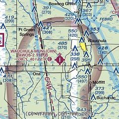
| Sectional chart |
|---|
|
CAUTION: Diagram may not be current

| Airport distance calculator |
|---|
|
|
| Sunrise and sunset |
|---|
|
Times for 29-Jan-2026
| | Local
(UTC-5) | | Zulu
(UTC) |
|---|
| Morning civil twilight | | 06:52 | | 11:52 |
| Sunrise | | 07:16 | | 12:16 |
| Sunset | | 18:05 | | 23:05 |
| Evening civil twilight | | 18:30 | | 23:30 |
|
| Current date and time |
|---|
| Zulu (UTC) | 29-Jan-2026 15:08:46 |
|---|
| Local (UTC-5) | 29-Jan-2026 10:08:46 |
|---|
|
| METAR |
|---|
KBOW
26nm N | 291500Z AUTO 02009KT 10SM CLR 12/M02 A3029 RMK AO2 PWINO
|
KLAL
28nm N | 291350Z 04005KT 10SM SKC 06/02 A3027
|
KSEF
29nm E | 291455Z AUTO 03009KT 10SM CLR 12/01 A3029 RMK AO2 T01160006
|
KAGR
30nm E | 291455Z AUTO 03008KT 7SM CLR 13/M00 A3026 RMK AO2 SLP249 T01271002 53004 $
|
KPCM
33nm NW | 291455Z AUTO 03007KT 10SM CLR 12/01 A3031 RMK AO2
|
KGIF
34nm N | 291453Z AUTO 03009KT 10SM CLR 11/00 A3030 RMK AO1 SLP260 6//// T01110000 53005 $
|
KPGD
36nm S | 291453Z 05013KT 10SM CLR 12/M01 A3029 RMK AO2 SLP255 T01171006 53008
|
KSRQ
37nm W | 291453Z 04008KT 10SM CLR 12/00 A3028 RMK AO2 SLP254 T01170000 53011 $
|
KMCF
39nm NW | 291455Z AUTO 05009KT 10SM CLR 12/M01 A3029 RMK AO2 SLP260 T01201012 53010
|
KSPG
43nm W | 291453Z 05011KT 10SM CLR 12/01 A3028 RMK AO2 SLP253 T01220011 53012 $
|
|
| TAF |
|---|
KLAL
28nm N | 291139Z 2912/3012 VRB03KT P6SM SKC FM291500 05006KT P6SM SKC FM300100 VRB02KT P6SM SKC
|
|
| NOTAMs |
|---|
NOTAMs are issued by the DoD/FAA and will open in a separate window not controlled by AirNav.
|
|


