FAA INFORMATION EFFECTIVE 19 MARCH 2026
Location
| FAA Identifier: | ESN |
| Lat/Long: | 38-48-14.9760N 076-04-08.3650W
38-48.249600N 076-04.139417W
38.8041600,-76.0689903
(estimated) |
| Elevation: | 72.2 ft. / 22.0 m (surveyed) |
| Variation: | 10W (1985) |
| From city: | 2 miles N of EASTON, MD |
| Time zone: | UTC -4 (UTC -5 during Standard Time) |
| Zip code: | 21601 |
Airport Operations
| Airport use: | Open to the public |
| Activation date: | 02/1944 |
| Control tower: | yes |
| ARTCC: | WASHINGTON CENTER |
| FSS: | LEESBURG FLIGHT SERVICE STATION |
| NOTAMs facility: | ESN (NOTAM-D service available) |
| Attendance: | 0800-DUSK |
| Pattern altitude: | TPA FOR JET ACFT 1526 FT AGL; ALL OTHER ACFT 1026 FT AGL. |
| Wind indicator: | lighted |
| Segmented circle: | yes |
| Lights: | WHEN TWR CLSD ACTVT REILS RWY 15, 22, & 33; HIRL RWY 04/22; MIRL RWY 15/33 - CTAF. |
| Beacon: | white-green (lighted land airport)
Operates sunset to sunrise. |
Airport Communications
| CTAF: | 118.525 |
| ATIS: | 124.475 |
| WX AWOS-3PT: | 124.475 (410-822-2817) |
| EASTON GROUND: | 119.075 [0600-2200] |
| EASTON TOWER: | 118.525 [0600-2200] |
| POTOMAC APPROACH: | 133.75 124.55 |
| POTOMAC DEPARTURE: | 133.75 124.55 |
| CLEARANCE DELIVERY: | 119.075 |
| TERPZ DP: | 133.75 |
| WX AWOS-3 at W29 (16 nm NW): | 120.575 (410-643-8795) |
| WX AWOS-3 at CGE (16 nm S): | 120.675 (410-228-7559) |
Nearby radio navigation aids
| VOR radial/distance | | VOR name | | Freq | | Var |
|---|
| BALr140/35.3 | | BALTIMORE VORTAC | | 115.10 | | 11W |
| ENOr234/36.4 | | SMYRNA VORTAC | | 111.40 | | 09W |
| ADWr100/37.3 | | ANDREWS VORTAC | | 113.10 | | 10W |
Airport Services
| Fuel available: | 100LL JET-A |
| Parking: | tiedowns |
| Airframe service: | MAJOR |
| Powerplant service: | MAJOR |
| Bottled oxygen: | LOW |
| Bulk oxygen: | NONE |
Runway Information
Runway 4/22
| Dimensions: | 5500 x 100 ft. / 1676 x 30 m |
| Surface: | asphalt/grooved, in good condition |
| Weight bearing capacity: | | Single wheel: | 40.0 | | Double wheel: | 60.0 | | Double tandem: | 100.0 |
|
| Runway edge lights: | high intensity |
| RUNWAY 4 | | RUNWAY 22 |
| Latitude: | 38-47.843838N | | 38-48.624513N |
| Longitude: | 076-04.317702W | | 076-03.729993W |
| Elevation: | 36.0 ft. | | 72.2 ft. |
| Traffic pattern: | left | | right |
| Runway heading: | 041 magnetic, 031 true | | 221 magnetic, 211 true |
| Displaced threshold: | no | | 325 ft. |
| Declared distances: | TORA:5175 TODA:5500 ASDA:4775 LDA:4775 | | TORA:5500 TODA:5500 ASDA:5500 LDA:5175 |
| Markings: | precision, in fair condition | | nonprecision, in good condition |
| Visual slope indicator: | 4-light PAPI on left (3.00 degrees glide path) | | 4-light PAPI on left (3.00 degrees glide path) |
| Runway end identifier lights: | no | | yes |
| Touchdown point: | yes, no lights | | yes, no lights |
| Instrument approach: | ILS/DME | | |
Runway 15/33
| Dimensions: | 4003 x 100 ft. / 1220 x 30 m |
| Surface: | asphalt, in good condition |
| Weight bearing capacity: | | Single wheel: | 40.0 | | Double wheel: | 60.0 | | Double tandem: | 100.0 |
|
| Runway edge lights: | medium intensity |
| RUNWAY 15 | | RUNWAY 33 |
| Latitude: | 38-48.514160N | | 38-48.027402N |
| Longitude: | 076-04.582425W | | 076-04.013928W |
| Elevation: | 32.6 ft. | | 51.0 ft. |
| Traffic pattern: | left | | right |
| Runway heading: | 148 magnetic, 138 true | | 328 magnetic, 318 true |
| Markings: | nonprecision, in fair condition | | nonprecision, in fair condition |
| Visual slope indicator: | 2-light PAPI on left (3.50 degrees glide path) | | 2-light PAPI on left (3.50 degrees glide path) |
| Runway end identifier lights: | yes | | yes |
| Touchdown point: | yes, no lights | | yes, no lights |
| Obstructions: | none | | 77 ft. trees, 1999 ft. from runway, 281 ft. right of centerline, 23:1 slope to clear |
Airport Ownership and Management from official FAA records
| Ownership: | Publicly-owned |
| Owner: | TALBOT CO
TALBOT COUNTY COURT HOUSE, 11 NORTH WASHINGTON STREET
EASTON, MD 21601
Phone 410-770-8082 |
| Manager: | MICAH RISHER
29051 CORKRAN ROAD
EASTON, MD 21601
Phone 410-770-8055 |
Additional Remarks
| - | DEER, BIRDS, OTHER WILDLIFE ON & INVOF ARPT. |
| - | RWY 15/33 DISTANCE MARKERS EVERY 1000 FT WEST SIDE RWY. |
| - | FOR CD WHEN ATCT IS CLSD CTC POTOMAC APCH AT 866-429-5882. |
| - | NOISE ABATEMENT FOR RUNWAY 22: CONTINUE STRAIGHT OUT OR MAKE A RIGHT TURN TO AVOID OVERFLIGHT OF THE TOWN OF EASTON. DEPARTURES SHOULD AVOID OVERFLIGHT OF THE TOWN OF EASTON BELOW 2000 FT. |
| - | AIRCRAFT SHOULD AVOID OVERFLIGHT OF THE TOWN OF EASTON AND RESIDENTIAL AREAS NEAR THE AIRPORT TO THE EXTENT POSSIBLE. |
| - | NOISE ABATEMENT FOR RUNWAY 4: IF TRAFFIC PERMITS, MAKE A SLIGHT LEFT TURN AFTER DEPARTURE TO AVOID OVERFLYING RETIREMENT COMMUNITY. |
Instrument Procedures
NOTE: All procedures below are presented as PDF files. If you need a reader for these files, you should download the free Adobe Reader.NOT FOR NAVIGATION. Please procure official charts for flight.
FAA instrument procedures published for use from 19 March 2026 at 0901Z to 16 April 2026 at 0900Z.
IAPs - Instrument Approach Procedures |
|---|
| ILS OR LOC RWY 04 **CHANGED** | |
download (280KB) |
| RNAV (GPS) RWY 04 **CHANGED** | |
download (277KB) |
| RNAV (GPS) RWY 15 **CHANGED** | |
download (250KB) |
| RNAV (GPS) RWY 22 **CHANGED** | |
download (263KB) |
| RNAV (GPS) RWY 33 **CHANGED** | |
download (237KB) |
| NOTE: Special Alternate Minimums apply | |
download (152KB) |
Departure Procedures |
|---|
| CONLE FIVE (RNAV) | |
download (171KB) |
| FOXHL ONE (RNAV) | |
download (151KB) |
| LINSE TWO (RNAV) | |
download (159KB) |
| TERPZ EIGHT (RNAV) | |
2 pages:
[1] [2] (295KB) |
| NOTE: Special Take-Off Minimums/Departure Procedures apply | |
download (366KB) |
Other nearby airports with instrument procedures:
KRJD - Gooden Airpark (14 nm NE)
W29 - Bay Bridge Airport (16 nm NW)
KCGE - Cambridge-Dorchester Regional Airport (16 nm S)
KANP - Lee Airport (25 nm W)
N06 - Laurel Airport (27 nm SE)
|
|

Road maps at:
MapQuest
Bing
Google
| Aerial photo |
|---|
WARNING: Photo may not be current or correct
 Photo taken 24-Aug-2016
looking north.
Photo taken 24-Aug-2016
looking north.
Do you have a better or more recent aerial photo of Easton Airport/Newnam Field that you would like to share? If so, please send us your photo.
|
| Sectional chart |
|---|
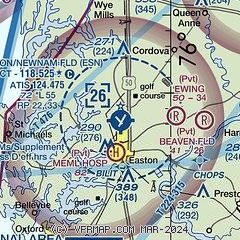
|
CAUTION: Diagram may not be current
 Download PDF
of official airport diagram from the FAA
| Airport distance calculator |
|---|
|
|
| Sunrise and sunset |
|---|
|
Times for 07-Apr-2026
| | Local
(UTC-4) | | Zulu
(UTC) |
|---|
| Morning civil twilight | | 06:14 | | 10:14 |
| Sunrise | | 06:41 | | 10:41 |
| Sunset | | 19:32 | | 23:32 |
| Evening civil twilight | | 19:59 | | 23:59 |
|
| Current date and time |
|---|
| Zulu (UTC) | 07-Apr-2026 07:28:43 |
|---|
| Local (UTC-4) | 07-Apr-2026 03:28:43 |
|---|
|
| METAR |
|---|
| KESN | 070655Z AUTO 00000KT 8SM CLR 07/06 A3008 RMK AO2 T00700059
|
KCGE
16nm S | 070655Z AUTO 00000KT 10SM CLR 07/07 A3008 RMK A01
|
|
| TAF |
|---|
KDOV
34nm NE | 070113Z 0701/0806 25006KT 9999 SCT100 QNH3005INS TEMPO 0701/0703 18006KT 9000 -RA FEW030 BKN100 TEMPO 0703/0706 9000 -RA FEW030 BKN100 BECMG 0706/0707 30008KT 9999 SCT100 QNH3006INS BECMG 0712/0713 31012G18KT 9999 FEW060 QNH3020INS BECMG 0714/0715 32015G25KT 9999 FEW060 QNH3024INS BECMG 0717/0718 34015G25KT 9999 SKC QNH3027INS TEMPO 0721/0723 35012G18KT BECMG 0723/0724 36012KT 9999 SKC QNH3036INS TX12/0701Z TN06/0710Z
|
KMTN
35nm NW | 070532Z 0706/0806 00000KT P6SM BKN070 FM070700 31007KT P6SM BKN090 FM071300 31013G23KT P6SM SKC FM072300 33009KT P6SM SKC
|
KNHK
36nm SW | 061500Z 0615/0715 32011KT 9999 FEW050 SCT250 QNH3007INS BECMG 0617/0619 14010G18KT 9999 FEW050 SCT250 540107 542409 533309 QNH3004INS BECMG 0621/0623 20006KT 9999 FEW040 BKN080 BKN250 650705 542409 533309 QNH3004INS FM070800 32010G18KT 9999 BKN250 600000 500000 QNH3011INS TX16/0620Z TN08/0711Z FN20119
|
KBWI
36nm NW | 070532Z 0706/0812 VRB04KT P6SM BKN090 FM070700 31007KT P6SM BKN090 FM071300 31015G26KT P6SM SKC FM072300 34010KT P6SM SKC FM080500 01005KT P6SM SKC
|
KADW
37nm W | 070100Z 0701/0807 10006KT 9999 BKN100 QNH3005INS BECMG 0703/0704 VRB06KT 9999 FEW080 QNH3005INS BECMG 0705/0706 32006KT 9999 FEW080 QNH3008INS BECMG 0709/0710 31012G18KT 9999 FEW050 510104 QNH3014INS BECMG 0710/0711 31015G25KT 9999 FEW030 SCT060 510005 QNH3018INS BECMG 0801/0802 36012G18KT 9999 SKC QNH3030INS TX13/0721Z TN06/0801Z
|
KSBY
39nm SE | 070531Z 0706/0806 20005KT P6SM SCT100 BKN250 FM071100 32008KT P6SM SCT250 FM071400 32015G24KT P6SM FEW250 FM080000 35008KT P6SM SKC
|
|
| NOTAMs |
|---|
NOTAMs are issued by the DoD/FAA and will open in a separate window not controlled by AirNav.
|
|


