FAA INFORMATION EFFECTIVE 19 MARCH 2026
Location
| FAA Identifier: | UKT |
| Lat/Long: | 40-26-06.5000N 075-22-55.0000W
40-26.108333N 075-22.916667W
40.4351389,-75.3819444
(estimated) |
| Elevation: | 525.1 ft. / 160.1 m (surveyed) |
| Variation: | 12W (2005) |
| From city: | 2 miles W of QUAKERTOWN, PA |
| Time zone: | UTC -4 (UTC -5 during Standard Time) |
| Zip code: | 18951 |
Airport Operations
| Airport use: | Open to the public |
| Activation date: | 11/1946 |
| Control tower: | no |
| ARTCC: | NEW YORK CENTER |
| FSS: | WILLIAMSPORT FLIGHT SERVICE STATION |
| NOTAMs facility: | UKT (NOTAM-D service available) |
| Attendance: | 0830-1700 |
| Wind indicator: | lighted |
| Segmented circle: | no |
| Lights: | DUSK-DAWN. ACTVT REIL RWY 11 & 29; MIRL 11/29 - CTAF. |
| Beacon: | white-green (lighted land airport)
Operates sunset to sunrise. |
Airport Communications
| CTAF/UNICOM: | 122.725 |
| WX AWOS-3: | 119.475 (215-538-7610) |
| PHILADELPHIA APPROACH: | 123.8 |
| PHILADELPHIA DEPARTURE: | 123.8 |
| CLEARANCE DELIVERY: | 118.55 |
| WX AWOS-3 at CKZ (5 nm SE): | 126.325 (215-257-7291) |
| WX AWOS-3 at XLL (9 nm NW): | 127.875 (610-231-3111) |
| WX ASOS at ABE (13 nm N): | 126.975 (610-477-0813) |
| WX ASOS at DYL (13 nm SE): | 118.875 (215-345-0392) |
| WX ASOS at PTW (14 nm SW): | 119.425 (610-495-0823) |
| WX AWOS-3 at LOM (19 nm S): | 118.925 (215-646-1068) |
| WX AWOS-3 at N40 (20 nm NE): | 121.725 |
- CLEARANCE DELIVERY PHILADELPHIA APCH TF 800-354-9884.
Nearby radio navigation aids
| VOR radial/distance | | VOR name | | Freq | | Var |
|---|
| PTWr042/15.2 | | POTTSTOWN VORTAC | | 116.50 | | 09W |
| ETXr131/16.3 | | EAST TEXAS VOR/DME | | 110.20 | | 09W |
| FJCr179/17.8 | | ALLENTOWN VORTAC | | 117.50 | | 10W |
| ARDr307/24.3 | | YARDLEY VOR/DME | | 108.20 | | 10W |
| SBJr263/30.5 | | SOLBERG VOR/DME | | 112.90 | | 10W |
| BWZr240/33.6 | | BROADWAY VOR/DME | | 114.20 | | 11W |
| MXEr032/33.7 | | MODENA VORTAC | | 113.20 | | 09W |
Airport Services
| Fuel available: | 100LL
100LL:100 LL AVBL 24 HRS SELF-SERVE CREDIT CARD. |
| Parking: | tiedowns |
| Airframe service: | MAJOR |
| Powerplant service: | MAJOR |
| Bottled oxygen: | NONE |
| Bulk oxygen: | NONE |
Runway Information
Runway 11/29
| Dimensions: | 3210 x 75 ft. / 978 x 23 m |
| Surface: | asphalt, in good condition |
| Weight bearing capacity: | |
| Runway edge lights: | medium intensity |
| RUNWAY 11 | | RUNWAY 29 |
| Latitude: | 40-26.149525N | | 40-26.068135N |
| Longitude: | 075-23.258947W | | 075-22.575312W |
| Elevation: | 525.1 ft. | | 505.1 ft. |
| Traffic pattern: | left | | left |
| Runway heading: | 111 magnetic, 099 true | | 291 magnetic, 279 true |
| Displaced threshold: | no | | 190 ft. |
| Declared distances: | TORA:3210 TODA:3210 | | TORA:3210 TODA:3210 |
| Markings: | nonprecision, in good condition | | nonprecision, in good condition |
| Visual slope indicator: | 2-light PAPI on left (4.00 degrees glide path) | | 2-light PAPI on left (4.00 degrees glide path) |
| Runway end identifier lights: | yes | | yes |
| Touchdown point: | yes, no lights | | yes, no lights |
| Obstructions: | 77 ft. trees, 613 ft. from runway, 275 ft. right of centerline, 5:1 slope to clear | | 27 ft. tree, 213 ft. from runway, 166 ft. left of centerline
APCH SLP 15:1 TO 190 FT DTHR. |
Airport Ownership and Management from official FAA records
| Ownership: | Publicly-owned |
| Owner: | BUCKS COUNTY AIRPORT AUTH
OLD EASTON RD, PO BOX 1185
DOYLESTOWN, PA 18901
Phone 215-345-1970 |
| Manager: | PHIL REINFORD
2425 MILFORD SQUARE PIKE
QUAKERTOWN, PA 18951
Phone 215-720-9715 |
Additional Remarks
| - | DEER ON & INVOF ARPT. |
| - | ACFT WITH WING SPAN GREATER THAN 54.5 FEET MUST COORDINATE WITH AMGR. |
| - | FOR CD CTC PHILADELPHIA APCH AT 800-354-9884. |
Instrument Procedures
NOTE: All procedures below are presented as PDF files. If you need a reader for these files, you should download the free Adobe Reader.NOT FOR NAVIGATION. Please procure official charts for flight.
FAA instrument procedures published for use from 19 March 2026 at 0901Z to 16 April 2026 at 0900Z.
IAPs - Instrument Approach Procedures |
|---|
| RNAV (GPS) RWY 11 | |
download (197KB) |
| RNAV (GPS) RWY 29 | |
download (202KB) |
| NOTE: Special Alternate Minimums apply | |
download (34KB) |
| NOTE: Special Take-Off Minimums/Departure Procedures apply | |
download (149KB) |
Other nearby airports with instrument procedures:
KCKZ - Pennridge Airport (5 nm SE)
KXLL - Allentown Queen City Municipal Airport (9 nm NW)
KABE - Lehigh Valley International Airport (13 nm N)
KDYL - Doylestown Airport (13 nm SE)
KPTW - Heritage Field Airport (14 nm SW)
N47 - Pottstown Municipal Airport (17 nm SW)
KLOM - Wings Field Airport (19 nm S)
N85 - Alexandria Airport (19 nm NE)
N43 - Braden Airpark (19 nm N)
N40 - Sky Manor Airport (20 nm NE)
|
|

Road maps at:
MapQuest
Bing
Google
| Aerial photo |
|---|
WARNING: Photo may not be current or correct
 Photo by Salvatore A. Boccuti www.salboccuti.com
Photo taken 23-Mar-2008
Photo by Salvatore A. Boccuti www.salboccuti.com
Photo taken 23-Mar-2008
Do you have a better or more recent aerial photo of Quakertown Airport that you would like to share? If so, please send us your photo.
|
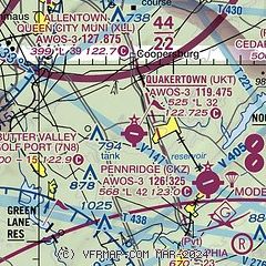
| Sectional chart |
|---|
|
| Airport distance calculator |
|---|
|
|
| Sunrise and sunset |
|---|
|
Times for 06-Apr-2026
| | Local
(UTC-4) | | Zulu
(UTC) |
|---|
| Morning civil twilight | | 06:11 | | 10:11 |
| Sunrise | | 06:38 | | 10:38 |
| Sunset | | 19:30 | | 23:30 |
| Evening civil twilight | | 19:58 | | 23:58 |
|
| Current date and time |
|---|
| Zulu (UTC) | 06-Apr-2026 13:16:37 |
|---|
| Local (UTC-4) | 06-Apr-2026 09:16:37 |
|---|
|
| METAR |
|---|
| KUKT | 061255Z AUTO 28011G18KT 250V310 10SM CLR 06/M04 A3007 RMK AO2
|
KCKZ
5nm SE | 061255Z AUTO 30013G22KT 10SM CLR 06/M05 A3007 RMK AO2
|
KXLL
9nm NW | 061255Z AUTO 28011G16KT 10SM SCT046 06/M04 A3009 RMK AO2 TSNO
|
KABE
13nm N | 061251Z 28012G21KT 10SM CLR 06/M04 A3007 RMK AO2 SLP184 T00611044 $
|
KDYL
14nm SE | 061254Z AUTO 31013G22KT 10SM CLR 07/M04 A3007 RMK AO2 SLP183 T00721044
|
KPTW
14nm SW | 061254Z AUTO 31015G23KT 10SM CLR 07/M05 A3010 RMK AO2 SLP189 T00671050 $
|
KLOM
19nm S | 061250Z AUTO 31009G15KT 10SM CLR 07/M03 A3008 RMK AO2 T00681034
|
|
| TAF |
|---|
KABE
13nm N | 061120Z 0612/0712 30009KT P6SM SKC FM061400 29011G17KT P6SM FEW060 FM061700 27012G20KT P6SM BKN050 FM062300 27005KT P6SM SCT070 FM070800 29008KT P6SM FEW020
|
|
| NOTAMs |
|---|
NOTAMs are issued by the DoD/FAA and will open in a separate window not controlled by AirNav.
|
|

